Showing posts with label Rattlesnake National Recreation Area and Wilderness. Show all posts

October 12, 2014

Celebrating wilderness with solitude in Rattlesnake

boulder_lake_2014-09-01_052

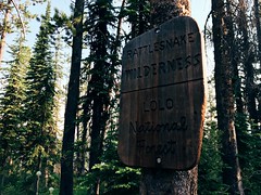
I spent a lot of time in the Rattlesnake National Recreation Area and Wilderness this past summer, so it was only fitting that when we chose a place to hike two days before the 50th anniversary of the Wilderness Act it was there.

While the Rattlesnake is Missoula's backyard, accessed by most from the main trailhead on the north edge of the city, we hiked to Boulder Lake from the more remote West Fork of Gold Creek to the northeast and saw only two other people all day. The rough drive into the trailhead likely accounts for the decreased use - it's the only time the traction control light in our SUV has turned on on a dry road.

boulder_lake_2014-09-01_008

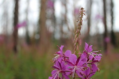
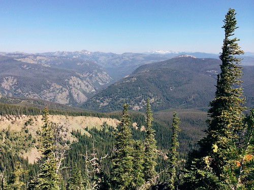
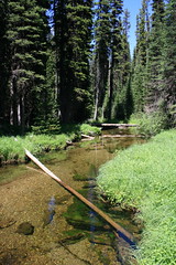
Once there, we hiked north on Trail 333 through an old burn, the Mineral Peak lookout visible to the south through the remaining snags and tall stalks of fireweed. The trail rose and fell gradually, crossed a couple of creeks, then entered forest just before a junction at 2 1/2 miles.

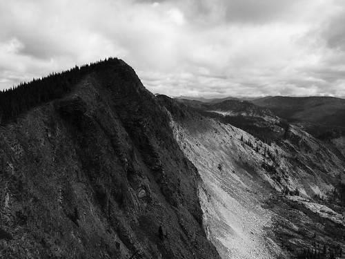
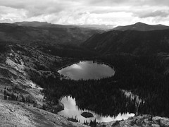
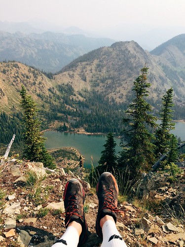
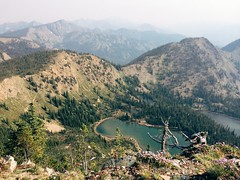
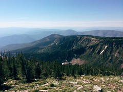
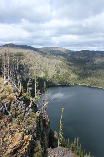
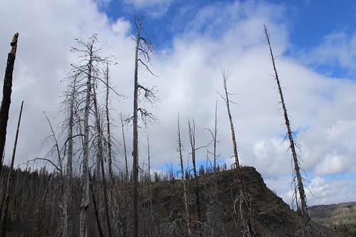
Continuing on Trail 333 to the northwest, we climbed a burned ridge, passing the wilderness boundary at 3 3/4 miles. From there, the trail continued up to a saddle below 7,293-foot Boulder Point. A short distance higher, we hiked a 1/4-mile side trail to the point, where we found the remains of lookout and views 800 feet down to the lake, north to the Mission Mountains and northeast the the Swan Range.

boulder_lake_2014-09-01_035

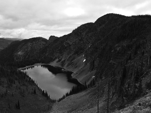
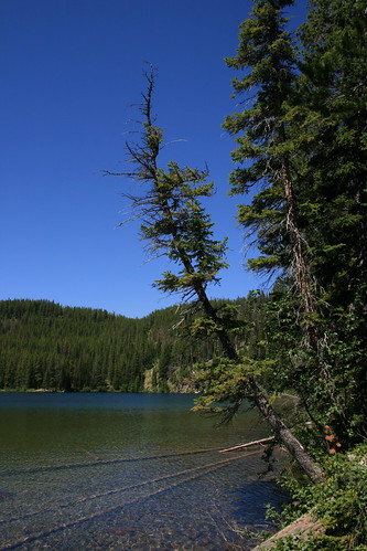
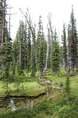
After returning to Trail 333, we continued up into the forest and a junction at 5 miles. Here, we followed the final steep switchbacks down 1 mile along a creek and past a marshy area, then down more to the lake shore and the point looming to the west.

boulder_lake_2014-09-01_082

After eating some food and letting the dogs swim and sniff around some moose tracks, we climbed up from the lake and hiked back to our car.

In Missoula, we truly are lucky to have treasures such as the Rattlesnake Wilderness - and the Selway-Bitterroot, Mission Mountains and Bob Marshall - so close.

Here are more photos from Boulder Lake.

Distance: 12 1/2 miles round trip, including 1/2 to Boulder Point and back.

Trailhead: From Bonner, drive about 8 3/4 miles east on Montana Highway 200, then turn northwest on Gold Creek Road, also known as Forest Road 126, and follow it 6 miles. Turn northwest on Forest Road 2103 and continue 5 miles, then turn onto Forest Road 4323 and continue 5 rough miles northwest to the West Fork Gold Creek trailhead.

October 11, 2014

Late-summer loop to Rattlesnake's Mosquito Peak

Mosquito Peak in the Rattlesnake Wilderness

Back in August, a friend and I set out early one morning on what would be our final long run before The Rut 50K, a 32-mile loop to Mosquito Peak in the Rattlesnake Wilderness.

The route took us up the Spring Gulch and down Rattlesnake Creek - trails we had covered earlier in the summer - linking them with the Wrangle Creek drainage. We had never been beyond Stuart Peak in the wilderness and were there on a smoky morning earlier in the summer; despite clouds overhead, we were rewarded this time with better views of the surrounding peaks.

Starting from the main trailhead for the Rattlesnake National Recreation Area, we followed Trail 515 half a mile north then turned up Spring Gulch on Trail 517. We followed this trail north as it rose above Spring Creek and switchbacked to the wilderness boundary at about 7 3/4 miles. From there, we continued as the trail steadily rose and fell on and alongside the ridgeline, past the Twin Lakes below Stuart Peak, then McKinley Lake and Worden Lake.

Big Lake, below Mosquito Peak in the Rattlesnake Wilderness

At about 11 1/2 miles, we veered northeast off the trail for a rougher route along the cliff edge, over a false summit and to 8,057-foot Mosquito Peak at about 12 miles. We stopped here to eat and take in the view of Big Lake, Little Lake and Glacier Lake below, and Point Six to the west, McLeod Peak to the north and Mineral Peak to the southeast.

Glacier Lake in the Rattlesnake Wilderness

After our break, we continued downhill to the northwest and back to Trail 517, then north slightly to the junction with Trail 502 above Glacier Lake at 12 3/4 miles. Here, we turned northeast on 502 and continued downhill past Glacier Lake, then stopped briefly at Little Lake. Back in the forest, we encountered too many downed trees over the trail as we switchbacked into the Wrangle Creek drainage.

Continuing east along the creek, we left the wilderness at about 18 miles near the confluence with Rattlesnake Creek. After crossing a concrete bridge over the creek where it cut down through bedrock, we rejoined the main Trail 515.

From there, it was about 14 miles back along the wide trail as it dropped to Franklin Bridge, then rose slightly beyond Poe meadow. After passing only two other people in the first 18 miles, we encountered several mountain bikers and hikers, then a full parking lot at the end.

In 7 hours and 45 minutes, we gained nearly 5,300 feet of elevation over more than 32 miles. Three weeks later at The Rut, we would need to double the gain and reach the 11,000-foot summit of Lone Peak in the same distance.

July 20, 2014

A smoky run up Stuart Peak

My feet atop Stuart Peak

Wildfire smoke filling the valley last week didn't deter a friend and I from getting out on a long run Saturday morning - in fact, an early start provided a short, clear window on our way up 7,971-foot Stuart Peak in the Rattlesnake Wilderness.

Looking up from the main Rattlesnake National Recreation Area trailhead we could see blue sky, but on the way down summer's heat and smoke from out-of-state fires set in.

We started out somewhat early following the main trail, Trail 515, north for 2/3 of a mile. From there, we followed the shadier Trail 517.1 up the east side of Spring Creek for about 1 2/3 miles, then crossed over to Trail 517 on the west side and continued. After the Wallman Trail veered off at about 3 miles, the trail began a steep section, reaching at junction with Trail 24.1 from the west at about 4 1/4 miles.

Rattlesnake Wilderness sign on the Stuart Peak trail

From the junction, we continued northeast on 517 up a couple of long stretches and a couple of series of switchbacks, the forest thinning and beargrass increasingly blooming as we rose. At 7 3/4 miles we reached the top of the switchbacks and the Rattlesnake Wilderness boundary. From there, we continued 1 1/4 miles on a flat to slightly uphill stretch to an overlook of Twin Lakes.

The final stretch followed a steep, rough trail along the ridgline to the southeast from Trail 517 about 1/2 mile to Stuart Peak, bringing our elevation gain to more than 4,200 feet. Most days, you can see south to Missoula and the Bitterroot Mountains or north across the wilderness to the Mission and Swan ranges. With the smoke however, we could see only the lakes below and other mountains in the immediate area.

Smoke and sun on my run up Stuart Peak

After stopping at the top for some photos and to eat, we backtracked to the trailhead, finding it hotter and smokier than when we left about 4 hours and 15 minutes earlier.


July 17, 2014

Sheep Mountain marathon before the marathon

My Missoula trail marathon today: Out Rattlesnake Creek, back over Sheep Mountain

Last Saturday - the day before the Missoula Marathon - a friend and I decided to run a marathon of our own up Rattlesnake Creek and back over Sheep Mountain and Blue Point.

The day was hot, so we started early, and after a few short side trips ended at 26 1/2 miles and nearly 5,100 feet of elevation gain.

My Missoula trail marathon today: Out Rattlesnake Creek, back over Sheep Mountain

From the main Rattlesnake National Recreation Area trailhead, we followed the wide Trail 515 for eight rolling miles to Franklin Bridge, stopping there to filter some water. A short distance up the hill from the bridge, we turned east on Trail 514 and climbed about 1 1/2 miles through the forest above the East Fork of the creek. When the trail reached another junction, we continued southeast downhill, still on 514, and crossed the creek, then climbed again through the forest thick with beargrass. At the next junction, a little more than 1 3/4 miles later, we continued southeast again a short distance until reaching Trail 513 between Sheep Mountain and Mineral Peak.

My Missoula trail marathon today: Out Rattlesnake Creek, back over Sheep Mountain

Turning west on 513, we followed the wide ridge southwest then switchbacked steeply up to the top of 7,646-foot Sheep Mountain at about 15 1/2 miles, where we took another break at a small stone-walled shelter. After eating and taking in the view, we continued about 3 3/4 miles along the open ridge over another small point, down below treeline and back up to the Blue Point junction. After a 1/2-mile out-and-back detour to the overlook, we returned to Trail 513 and followed the ridge down about 4 miles into Woods Gulch. After another brief stop to refill our packs with water, we continued west down to the trailhead and followed roads about a mile back to the main Rattlesnake trailhead.

After about six hot hours out we had our mountain marathon.

(Note: My GPS malfunctioned, resulting in all laps being recorded, but only half a map, so it isn't posted here.)

July 24, 2012

Dogs, elephants and mosquitoes on the trail to Fly Lake

fly_lake_20120718_035

With time off last week, I took a short hike with the dogs to a lake in the back of the Rattlesnake Wilderness and saw no one else on the trail.

Fly Lake is nestled among some small, forested mountains on the northern edge of the wilderness. Despite its name, it wasn't that buggy - but the trail there passes through prime mosquito habitat.

fly_lake_20120718_069

The route begins by dropping less than half a mile from the trailhead, then crossing Gold Creek. A logjam just upstream is passable if you don't want to get your feet wet. From here, the trail roughly parallels the creek northwest, though it isn't always visible, then turns back and crosses the water again at about 1 2/3 miles. Another logjam here is passable.

fly_lake_20120718_066

After turning west again, the trail arrives at a large, open meadow with several small channels of water crossing it. Look for wildflowers such as elephanthead and bog rein orchid along the edge of the forest at this time of year.

The next mile of trail was the buggiest when I was there, with standing water in several places and a lot of mud. At about 2 2/3 miles the trail again crosses the creek - there's another logjam, too - then arrives at a junction at about 3 miles.

From the junction, follow the trail to Fly Lake northwest as it climbs almost 1 1/2 miles out of the creek bottom, into drier terrain, then drops slightly to the lake. Friends have camped here in the past, but I've only ever day hiked in and out.

In addition to bugs, many downed trees crossed the trail when I was there - the worst blockage was about half a mile before the lake.

See more pictures from Fly Lake here.

Distance: About 8 3/4 miles out and back.

Trailhead: Fly Lake is accessed from the main Gold Creek trailhead (not West Fork). From Bonner, drive 8 1/2 miles northeast on Montana Highway 200. Turn north on Gold Creek Road and follow the signs 17 miles to the main trailhead along forest roads 126 and 2121.

June 13, 2009

The long run

I'm officially on the final stretch of training for the Missoula Marathon, having topped out with a 20-mile run this week. And it was quite a wild run.

First, while crossing over the North Hills, I saw that the bitterroots are beginning to bloom (I need to get back up there with my camera). In the residential part of the Rattlesnake Valley, I came across a few deer during their morning munching.

Then, just a mile up the main trail in the Rattlesnake National Recreation Area and eight miles into my run, I rounded a bend and found myself looking at a large bear about 100 feet away - and it was looking back at me.

In the end it wasn't all that big of a deal. I stopped, yelled and clapped at it, it stepped off the path, and I turned around and ran up a different trail. Sure, there's an initial adrenaline rush, but I've encountered bears while hiking before and know the protocols. Mostly, I was thrown off by having to change my route and refigure my mileage - and having to yell "Hey, bear!" - on the run.

As far as the marathon training is concerned, it's going great. I've been able to keep a steady pace on my long runs, and the recovery has gone well.

People have asked me several questions about my big double-digit days: Do I get tired? Not while running; afterward my legs feel like they've had a good workout. Sore? Not really after adjusting to the distance; that's the point of going slow and stretching. That's a lot of energy expended - what about food and water? I take some energy gummies and a hydration pack with me, and yes, it does mean carrying a few extra pounds. What about the final 6.2 miles? My trainer-friend says most marathoners only get up to 20 or 22 miles before the event and think of the last stretch as just another 10K.

I've got a couple of runs in the high teens left, then I taper off until the big day, Sunday, July 12. I'm looking forward to crossing the finish line.