September 28, 2012

Glacial exploration in southeast Iceland

jokulsarlon_20120909_252

The next stop after our trip inland in Iceland was Skaftafell in Vatnajökull National Park, where massive glaciers push down from the mountains along the country's southeastern coast.

seljalandsfoss_20120907_020

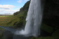
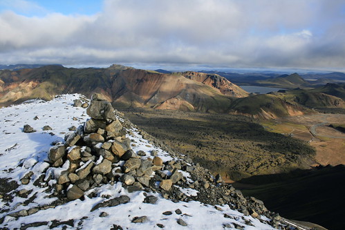
Along the way, we turned a short distance off of the Ring Road about 33 kilometers east of Hella and stopped to stretch our legs on a short trail at Seljalandsfoss. Here, water pours over a cliff into a grass-ringed pool 60 meters below. The walk leads behind the falls and a short distance along the cliff to two smaller cascades.

vatnajokull_20120907_070

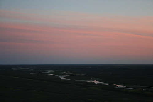
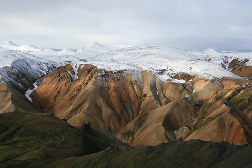
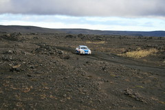
The last 125 kilometers of the drive to Skaftafell passes through the sandar - plains of dark gray glacial sand. The terrain is so level and view so unobstructed that the mountains of Vatnajökull could be seen nearly the entire way. The 1,000-square-kilometer Skeiðarársandur, just west of Skaftafell, is the largest glacial sand plain in the world, and the reflection of the setting sun on rivers running across it makes for an impressive sight.

Founded in 2008, Vatnajökull National Park merged two existing parks and other lands spanning Iceland from north to south. The resulting 14,000-square-kilometer park is the largest in Europe; the 8,100-square-kilometer glacier it is named for also is the largest on the continent.

vatnajokull_20120908_296

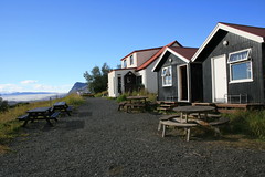
At Skaftafell, we stayed at the Bölti guesthouse, an old farmhouse on the hillside above the park visitor center and campground. It's likely one of the oddest accommodations we've stayed in on our travels. The property includes the main house, two small bunkhouses and another building with a shared kitchen. The decor and structures obviously have been added to over many years.

Late that afternoon, we strolled out an easy trail through a moraine and to a glacial lagoon. The next day, lacking the necessary equipment ourselves, we hiked on a glacier with a guided group. Later, we checked out a few waterfalls near the guesthouse. The day we departed, we stopped at another glacial lagoon filled with icebergs and seals.

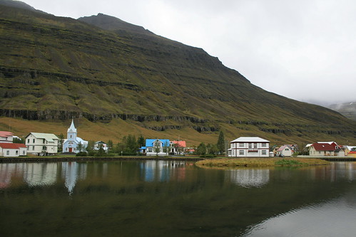
After the stop at the lagoon, we were on our way through Iceland's eastern fjords to the small, picturesque town of Seyðisfjörður for a night before traveling to the north of the country.

Our main takeaway from Vatnajökull was how small the glaciers in our own backyard are. (We've never been to Alaska.) North of our home in Missoula, sits Glacier National Park, where we often hike and cross-country ski. The park recently has been emphasizing its glacial geology, rather than the glaciers themselves. Vatnajökull really reinforces that Glacier is much closer to the end result of the process.

Day 1: Skaftafellsjökull moraine

vatnajokull_20120907_037

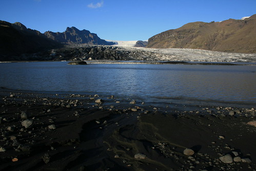
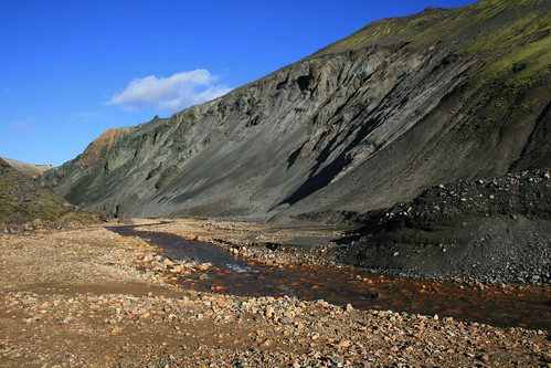
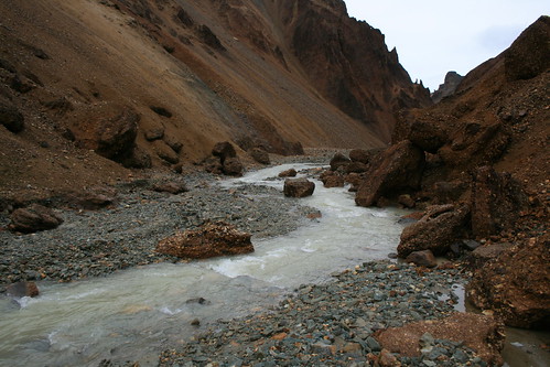
After a day of driving, the short and mostly level walk out the Skaftafellsjökull moraine to the lagoon at the base of the glacier was easy to do before dinner.

Leaving from the visitor center area, two parallel trails - one mostly paved and accessible, the other rougher - track northeast along the base of a mountain. At the lagoon, we explored the sandy beach for a little while and marveled in the size of the glacier, the returned the way we arrived.

Here are more pictures from the Skaftafellsjökull moraine.

Location: The trail begins north of the park visitor center at Skaftafell, 231 kilometers southeast of Hella on the Ring Road.

Day 2: Falljökull

vatnajokull_20120908_134

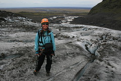
The next day, we woke early and made our way to one of the guide offices adjacent to the visitor center. We usually don't go on guided tours while traveling, but thought it wise this time because we wanted to get out on a glacier but lacked the proper safety equipment.

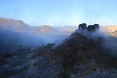
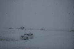
Our group was small, and only one of two that got an early start on Falljökull after a shuttle ride southeast of the visitor center. After a short walk through the moraine, we donned our crampons and ice axes and stepped onto the ice.

vatnajokull_20120908_045

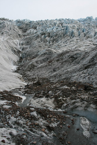
Looking at a map, you can tell that Falljökull is one of the smaller glaciers in the area, dwarfed by Skeiðarárjökull to the west, but it still was impressive. We've trekked through snowfields and on smaller glaciers in western Montana's mountains, and we'd never seen anything like the jagged blue-gray spires of ice above us up close.

The guide led us uphill to the northeast, stopping to explain glacial features such as caves, streams, crevasses, moulins and ice falls. Depending on where we were standing, the ice was 400 to 600 meters thick.

vatnajokull_20120908_030

As we continued up, we hopped small crevasses and listened for the delayed crack of rocks the guide dropped down moulins. When the angle of the glacier steepened at the bottom of an ice fall, we stopped for lunch.

vatnajokull_20120908_207

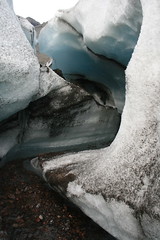
Soon, we were on our way back down a different route. Along the way, we stopped to step inside a water-carved channel through the ice, which was illuminated blue by the light from above.

After about five hours on Falljökull, we were back on the shuttle headed for the visitor center.

Here are more pictures from Falljökull.

Location: Falljökull is about 8 1/2 kilometers southeast of Skaftafell on the Ring Road, then up a short unpaved access road. Guide companies have offices across the parking lot from the park visitor center at Skaftafell.

Day 2: Svartifoss

vatnajokull_20120908_246

After returning to the guesthouse where we were staying, we set out on a nearby trail to explore the waterfalls and viewpoints uphill to the northeast.

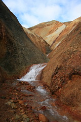
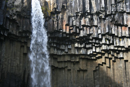
Shortly, we passed Hundafoss and Magnúsarfoss, then climbed higher. After reaching an open area, the trail turned west and dropped slightly to Svartifoss. This frequently photographed waterfall spills from a shelf into an amphitheater formed by basalt columns.

From there, we continued uphill to the west, then turned north on another trail and arrived at the Sjónarsker viewpoint. Here, we could take in peaks higher up, vast Skeiðarársandur and across it to the giant Skeiðarárjökull beyond.

Afterward, we turned south and followed the trail back to the guesthouse.

Here are more pictures from Svartifoss.

Location: The trail to Svartifoss begins at the park visitor center; we joined it uphill to the northwest, where it passes near the Bölti guesthouse.

Day 3: Jökulsárlón

jokulsarlon_20120909_159

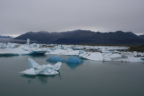
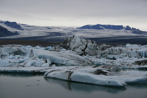
The next day was gray and rainy, and as we drove east from Skaftafell we stopped at Jökulsárlón, where large pieces of ice that have calved off of a glacier float in a lagoon just in from the coastline.

jokulsarlon_20120909_121

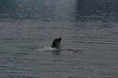
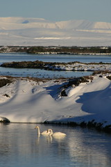
We arrived early enough to watch seals and birds feeding in the water after a short walk around the edge of the lagoon.

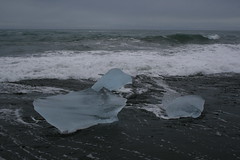
After a while, we crossed the Ring Road and briefly explored the black-sand beach, where smaller chunks of ice polished nearly transparent by the water wash ashore in the waves.

jokulsarlon_20120909_217

Here are more pictures from Jökulsárlón.

Location: Jökulsárlón is about 55 kilometers east of Skaftafell on the Ring Road. Parking is available on both sides of the outlet river; a visitor center is located on the east side.

September 25, 2012

On foot at Fjallabak Nature Reserve

fjallabak_20120906_069

Our first stopover in Iceland - and the place where we would spend the most time - was Fjallabak Nature Reserve, where trails climb into the rhyolite hills from the Landmannalaugar Hut.

Our intention was to backpack part of the well-known Laugavegur trail south to the Hrafntinnusker Hut, spend the night, then return to Landmannalaugar. However, when trying to reserve bunks in the huts in Reykjavík, we found Hrafntinnusker full. Instead, we stayed at Landmannalaugar for three nights and dayhiked in the area.

Getting to Landmannalaugar is a small adventure in and of itself. On the way that morning, we stopped at Geysir and Gullfoss to see the thermal area and waterfall. From there, we followed mostly paved roads south and east to connect with the main route into Fjallabak - the F208.

Iceland's F roads are mountain routes, similar to our forest roads. While some of these roads likely are passable in a two-wheel-drive vehicle, rental car companies will only allow four-wheel-drives on them - there are many signs, brochures and stickers warning of this - due to extreme terrain and river crossings.

The northwest segment of the F208, which we drove, is one of the more tame F roads, mostly being rocky and washboarded. At Landmannalaugar, however, you have a choice: About 200 meters before the hut, the road crosses two braids of a river with parking on each side. After stopping short, thinking we would walk our gear across a footbridge to the hut, we watched a couple of vehicles cross the stream and decided instead to ford it. It ended up being simpler than I thought, and even easier on the way out.

fjallabak_20120905_073

At the hut, we were assigned a room on the second floor with several bunks with sleeping pads. Lucky for us, only two other people were in the same room the first night, so we all could spread out our packs and sleeping bags. Unluckily, the room was full and noisy the second night. The last night was better with only four other people. The kitchen, on the main floor, was clean and well-stocked with pots, pans, dishes and utensils, and had several cooking stations. A separate washroom was equally spacious, with sinks in a common area and separate stalls for men and women. Several makeshift laundry lines were strung up by people drying swimwear after having soaked in the nearby hot springs-fed creek.

fjallabak_20120906_056

The afternoon we arrived was pleasant and we went on a short walk through a lava field. The second day, however, it rained nonstop. Even so, we trekked up a drainage, crossing a stream several times, until reaching snow blocking the end of it. The third day was partly sunny with a strong wind and fresh snow higher up. Still, we hiked over one mountain, up to a plateau then back over another mountain.

The next day, as we drove back to the Ring Road, we were forced to pull aside for about 1 1/2 hours to let a 22-car rally race pass on the F208. Once back on the main road, we went east across the sandar - glacial sand plains - to Skaftafell, at Vatnajökull National Park.

The following are our Landmannalaugar-based hikes. We bought a copy of "The Laugavegur Hiking Trail," published by Ferðafélag Íslands (the Iceland Touring Association), which contains a basic map and information on trails in the Landmannalaugar area. Unfortunately, it doesn't include distances.

Day 1: Grænagil and Laugahraun

fjallabak_20120904_033

We arrived at the Landmannalaugar Hut late in the afternoon, and after checking in there still was time for a short walk before dinner.

Hiking a short distance south of the hut, we turned southwest into Grænagil, the Green Ravine, named for the color of rhyolite found in the canyon. Here, the trail follows a stream between the Laugahraun lava field and the north flank of the mountain Bláhnúkur.

Soon, the trail leaves the water's edge and turns up into the lava field, where obsidian and patches of moss can be found. The rock is mostly stable, but likely would be painful to fall on. Colored stakes mark the route as it climbs partway up the mountain Brennisteinsalda and leaves the lava.

fjallabak_20120904_126

The trail from Grænagil connects with the Laugavegur trail at a steaming outcrop on the multicolored side of Brennisteinsalda. Turning north, we descended along the edge of the lava field to an open valley with the mountain Suðurnámur on the opposite side.

We finished the loop by turning east back through the lava and hiking down to Landmannalaugar.

Here are more photos from Grænagil and Laugahraun.

Day 2: Brandsgil

fjallabak_20120905_029

A downpour the second day at Landmannalaugar didn't deter our desire to go hiking, so we put on our rain gear and set out for Brandsgil on the advice of the guidebook - "ideal if there is a limited view of the mountains."

Walking south from the hut again, we passed Grænagil and continued along the flank of Bláhnúkur into Brandsgil, a deep but flat-bottomed canyon with a river flowing through it.

fjallabak_20120905_050

We followed the river up the canyon as it narrowed, crossing the stream several times and taking in the surrounding mountains and rock spires.

Near the end of the canyon, we reached a large snowfield that appeared impassable, although the guide notes a waterfall just beyond if you feel like scrambling. With the rain nonstop, we turned around and went back to the hut.

Here are more photos from Brandsgil.

Day 3: Bláhnúkur and Brennisteinsalda

fjallabak_20120906_048

We awoke the third day to see snow high on the surrounding mountains, but only partly cloudy skies and a breeze. The decent conditions allowed us to go on our longest hike while at Landmannalaugar.

South of the hut and just past Grænagil, we switchbacked south up the obsidian-black ridge of 945-meter-tall Bláhnúkur. With a strong wind blowing and a dusting of snow at the summit, we hunkered down for a few photos next to a round metal viewfinder that describes the surrounding mountains.

fjallabak_20120906_085

Over the top, we quickly descended west into Grænagil, crossing the stream at the bottom. Here, we briefly detoured to the south to a spot where a side channel spilled out of a narrow orange canyon. Retracing our steps, we joined the Grænagil trail and made our way to the steaming outcrop partway up Brennisteinsalda.

At the Laugavegur trail, we climbed southwest up the flank of Brennisteinsalda and continued on the path toward the Hrafntinnusker Hut. After reaching snow, we paused at a high point on the plateau to take in the view then turned around.

When the trail returned to the flank of Brennisteinsalda, we followed a route north to its 881-meter summit. Seeing the Vondugil below - as it went from wide and flat on the east end to narrow at the west - we descended the trail into the canyon.

fjallabak_20120906_202

At the bottom of  Brennisteinsalda, the wind subsided and we crossed the valley floor, past a stream and pond, back to the Laugavegur trail. From here, it was a short walk back over the Laugahraun lava field to Landmannalaugar.

Having been out all day, we ended with a soak in the hot-springs fed creek.

Here are more photos from Bláhnúkur and Brennisteinsalda.

Location: From the Ring Road just northwest of Hella, the Landmannalaugar Hut at Fjallabak Nature Reserve is 82 kilometers northeast on Route 26/F26, 26 km south on F208 and 2 km southwest on F224.

September 19, 2012

Water rises, falls at Geysir and Gullfoss

geysir_20120904_014

On the way to our first destination outside of Reykjavík, we left the Ring Road to see the Geysir thermal area and Gullfoss cascades.

geysir_20120904_048

According to information from the Geysir Center/Hotel Geysir, the Great Geysir is believed to be the namesake of geysers around the world, and geothermal activity in the area can be traced to earthquakes in the late 13th century. The Great Geysir went largely dormant in 1915, but has been more active since earthquakes in 2000. It currently erupts a few times a day to a height of 8 to 10 meters.

While we never saw the Great Geysir erupt, the nearby Strokkur geyser spouted several times during our stop. Since the early 1960s, Strokkur has been erupting 25 to 30 meters high every eight to 10 minutes. A network of short trails connects geothermal features in the area, but Strokkur is the main attraction.

gullfoss_20120904_071

A short distance up the road, is Gullfoss, a 32-meter double cascade where the Hvitá plunges into a narrow canyon and sends up a cloud of mist. Paths lead to a few viewpoints. Gullfoss.org relates the story of a failed effort to build a hydroelectric plant that would have destroyed the falls.

gullfoss_20120904_040

After stopping to see Geysir and Gullfoss, we went on our way to Fjallabak Nature Reserve for some hiking and a few nights in a mountain hut.

Here are more photos of Geysir and Gullfoss.

Location: From Selfoss on the Ring Road, Geysir is about 55 kilometers northeast on Route 35. Gullfoss is 15 km farther northeast on Route 35.

September 18, 2012

Reykjavík: Capital city start and finish

reykjavik_20120903_005

Our Icelandic holiday started and ended in the region around Reykjavík, the northernmost capital city in the world at 64 degrees 8 minutes above the equator.

While there is an airport in the city, most travelers from abroad arrive at Keflavík International Airport, about 50 kilometers southwest on the Reykjanes Peninsula. After a 7-hour 15-minute flight, we landed at 6:45 a.m. on a gray, rainy Monday. After picking up our rental SUV a short distance away from the airport, we drove the highway across the basalt-crusted peninsula into the city.

reykjavik_20120903_033

Our accommodations in Reykjavík were at a modern guesthouse just off the square containing Hallgrímskirkja, the tall white church that can be seen from miles away, a statue of the Viking Leifur Eiríksson and the Einar Jónsson Museum, with a sculpture garden behind it.

From the guesthouse, the city center was very walkable. The main street lies a short distance downhill from the church, past rows of colorful residences and businesses. In the area, we found cafes, restaurants, a bar serving only Icelandic beers, a supermarket, bookstores, several outdoor clothing retailers, squares and ponds - and few traffic signals. Despite the rain, it was packed with people wearing hoods and using umbrellas. Twenty-four hours later, after stocking up on supplies, we set out on the Ring Road to the southeast.

reykjavik_20120913_016

When we returned a week and a half later, the weather was better and the harbor could be seen from uphill near the church. We spent our last evening in Reykjavík using our remaining kronas and looking through the Jónsson sculpture garden.

The next day, before dropping off our rental vehicle and checking in at the airport, we stopped for a soak at the famed Blue Lagoon, 10 kilometers off the highway near Keflavík. It was an ideal way to get in one last bit of relaxation before the flights home!

reykjavik_20120914_003

Here are more photos of Reykjavík.

September 17, 2012

Iceland in numbers and words

We're fresh back from Iceland, and here are some random numerical and linguistic notes on our travels as I work on some more formal posts.

Numbers

1:30, 7:15 and 9: We had a 1-hour 30-minute flight from Missoula to Seattle and 7-hour 15-minute flight from Seattle to Keflavík International Airport, outside of Reykjavík. The layover in Seattle was nine hours. For some reason, we couldn't get a long enough layover on the return trip to pass through customs without spending nine hours sitting in Sea-Tac on the way there.

myvatn_20120910_002

1: Highway number of the Ring Road, which we mostly followed counterclockwise around Iceland from Keflavík, in the southwest corner.

1,833: Total number of kilometers driven on our route around the county.

90, 80 and 50: Primary speed limits in kilometers per hour - 90 on paved highways (about 55 mph), 80 on gravel roads (about 50 mph) and 50 in urban areas (about 30 mph).

262,5: Average price per liter for diesel we paid in Icelandic kronas. Equals about $8.23 per gallon in U.S. dollars. (Note that a comma is used in place of a decimal.)

4X4: Four-wheel drive, you need to rent a vehicle with it to get off the beaten path.

4: Number of stream crossings we made in our rented SUV - two branches of the same river twice in the Fjallabak Nature Reserve.

fjallabak_20120907_014

22: The number of rally cars we had to wait for to pass after discovering the mountain road we were driving out of Fjallabak Nature Reserve was being used for a race.

myvatn_20120911_002

7 and 8: Number of stops on our planned itinerary and number of actual stops we made after being forced to take shelter from an early snowstorm. Our planned itinerary was Reykjavík, Fjallabak, Skaftafell, Seyðisfjörður, Mývatn, Akureyri and back to Reykjavík. Between Seyðisfjörður and Mývatn, we were forced to spend the night on the Grímsstaðir farm due to a storm closing the highway.

25 1/2: Number of hours we spent holed up in a farmhouse at Grímsstaðir.

15 to 20: Amount of snow in centimeters that fell during the early storm in northern Iceland, according to the English-language news service Iceland Express. Equals 5.9 to 7.9 inches.

32 and 104: Top recorded gusts in meters per second east and west of the Grímsstaðir farm during the storm, according to the Iceland Met Office. Equals 71 and 232 mph.

900 and 415: Average price in kronas per 330-milliliter bottle of beer in pubs and state Vínbúðin stores, respectively. Equals $7.46 and $3.44 U.S., respectively. Buy at state stores. (BAC limit in Iceland is 0.05; don't drink and drive.)

30: The number of letters in the Icelandic alphabet. The four extras are ð, þ, æ and ö. Which brings me to ...

Language

The following are words likely to appear in upcoming posts either on their own or as a part of place names.

Eyjafjallajökull: The volcano that caused all the air travel disruptions in 2010. According to a T-shirt for sale in many gift shops there, it's pronounced "AY-uh-fyat-luh-YOE-kuutl-uh." We didn't see it, but I figure someone will ask.

seydisfjordur_20120909_007

Fjörður: fjord. The town Seyðisfjörður is on a fjord.

Foss: waterfall. Gullfoss is a 32-meter double cascade.

Geysir: The namesake of all geysers.

Hraun: lava field. Laugahraun is the lava field near the Landmannalaugar Hut in the Fjallabak Nature Reserve.

kull: glacier. There are several glaciers in Vatnajökull National Park.

Lón: lagoon. Jökulsárlón is a glacial lagoon. (See that - two!)

Sandur, sandar: glacial sand plain. Skeiðarársandur is the largest glacial sand plain in the world, at 1,000 square kilometers.

Staðir: place. Often a suffix on place names.

myvatn_20120912_012

Vatn: lake. Mývatn translates to Midge Lake.

Vík: bay. Reykjavík translates to Smoky Bay.