Training for this year's Missoula Marathon is well under way, and so far, so good.
The goal this year is to finish with the 3-hour, 40-minute group that I started my first marathon with last year, but fell back from. I finished that race at about 4:01.
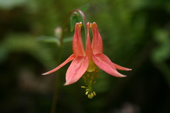
Pace-wise, 3:40 works out to about 8 minutes, 20 seconds per mile. In training, I've maintained that speed up through my 16-mile workouts, and all of my runs have been under last year's marathon pace of 9:16. I've got a couple of 20-milers under my belt that I ran at about 9 minutes per mile, but with those I also introduced some hills - 1,400-plus feet of elevation gain on the North Loop Trail at Mount Jumbo.
Those hills were part of a run-up to last weekend's Pengelly Double Dip, a fairly grueling half-marathon here from the valley floor up University Mountain and Mount Sentinel, then back down. It's billed as having 2,700 feet of elevation gain, but my GPS reported about that in elevation change from base to summit and nearly 3,300 feet of total gain.
Up until a few weeks ago, I had never really run anything like that. I've done the smaller Mount Jumbo a few times and some short segments of the Double Dip, and have hiked almost the entire course in the past, so am familiar with it.
Fresh back from a recent vacation, I ran the lower part of the course - up through the saddle but omitting the two summits for about 1,800 feet of gain - and felt good, so I decided to enter. Based on that training run, I figured I'd finish the Double Dip in about 2:30, which turned out to be fairly accurate as I came in at 2:34:41.
What I forgot about was how steep the upper part of the course is, particularly on University Mountain. In a couple of places, I don't know that anybody ran - all you could see was a line of single-file walkers. The downhill was much faster, but it was clear that many people fell from all the bloody knees and shins at the finish.
Below, you can see the basic details from my GPS; click through to the player and you can watch my run.
While rather difficult, the Double Dip was fun and rewarded with plenty of beautiful scenery, so I could see myself doing it again.
As for the Missoula Marathon, I've got a couple of weeks of long training runs left - including a 22-miler next week - before tapering off to conserve my energy for July 11. There may even be one more race in the lineup: the Mountain-to-Meadow half-marathon, a beautiful run through the forested mountains near Lolo Pass on the Montana-Idaho border.
June 14, 2010
June 4, 2010
Rain, and more rain
Last week, we spent most of our vacation in Olympic National Park in Washington, one of the wettest places in the continental United States - ideal for a spring vacation.
We went into the trip knowing we would probably see a lot of rain, and we were right. Our tent got soaked twice, and we were forced to bail out on camping and seek shelter in a cabin and with relatives. While camping was a bust, we still got out on foot in the Hoh Rain Forest, Sol Duc Valley and on the Pacific Coast. We did see some sun during our day at the beach, but a trip up Hurricane Ridge was pretty much a bust due to clouds.
See pictures from the entire trip here.
Hoh Rain Forest
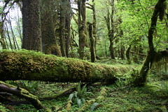
This classic Olympic hike tracks through temperate rain forest along the Hoh River. On the way, see dense, mossy forest and wildflowers. We hiked a short section after setting up camp the evening we arrived. We cooked and ate under a tarp rigged to the side of our car, and awoke to a soaked tent.
Distance: 17.5 miles one way to Glacier Meadows. (We hiked about 3 miles round trip.)
Trailhead: The trail begins at the Hoh Rain Forest Visitor Center, 13 miles south of Forks, Wash., on U.S. Highway 101, then 16 miles east on Upper Hoh Road.
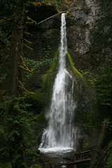
Sol Duc Valley
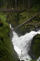
Our second and third nights in the park were spent in the Sol Duc Valley, first drying out in a cabin at Sol Duc Hot Springs Resort, then getting wet again in the campground. In between, we hiked the Lover's Lane Trail from the resort to Sol Duc Falls and back. More lush forest, cascading creeks and waterfalls.
Distance: 6 miles round trip.
Trailhead: The Lover's Lane Trail begins in the resort parking lot, 28 miles west of Port Angeles, Wash., on Highway 101 and 12 miles southeast on Sol Duc Hot Springs Road.
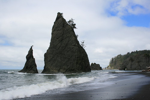
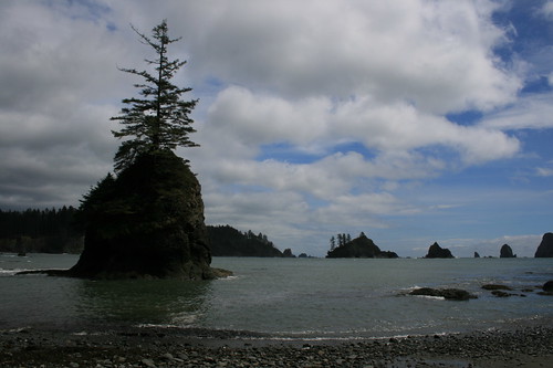
Rialto Beach
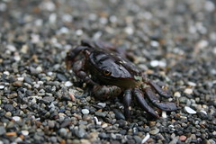
The first stop during our day at the coast was Rialto Beach, where we hiked north to sea stacks, Hole-in-the-Rock and beyond. Saw a lot of interesting polished rocks and driftwood, as well as a couple of small crabs.
Distance: 4 miles round trip.
Trailhead: From Forks, travel 1 1/2 miles north on Highway 101, then turn west on Highway 110 and follow it about 7 3/4 miles to Mora Road. Take Mora about five miles to the Rialto Beach trailhead.
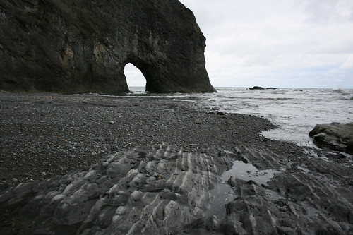
Third Beach and Taylor Point
With decent weather - hardly a drop of rain - and plenty of time, we opted for a second hike on our day at the coast. The trail begins in the forest before dropping to sandy Third Beach. A short distance down the beach, a second, muddy trail climbs up and over Taylor Point, dropping you at a bay filled with sea stacks.
Distance: 6 miles round trip.
Trailhead: From Forks, travel 1 1/2 miles north on Highway 101, then turn west on Highway 110 and follow it 12 miles to the trailhead, just before La Push.
Marymere Falls
We started the day by driving through heavy rain and fog to Cape Flattery, Wash. - the farthest northwest one can travel in the Lower 48 - and not walking to see the lighthouse there. When we returned to Lake Crescent, it was only sprinkling, so we took a short hike through the forest to Marymere Falls.
Distance: 1.8 miles round trip.
Trailhead: The trail begins at the Storm King Ranger Station, about 19 miles west of Port Angeles on Highway 101.
June 1, 2010
Gorge green
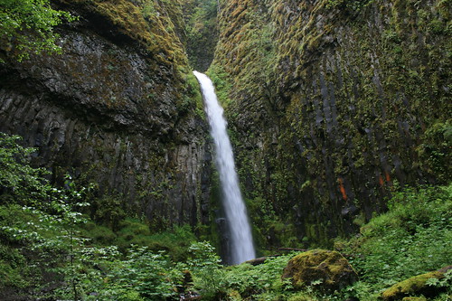
Last week, we started off our annual spring vacation with a walk through the lush Columbia River Gorge National Scenic Area east of Portland, Ore.
On the recommendation of Backpacker magazine, we linked segments of the Herman Creek, Pacific Crest and Dry Creek trails for a hike in the Mount Hood National Forest and Mark O. Hatfield Wilderness. There were plenty of green leaves, running creeks, wildflowers and a waterfall.
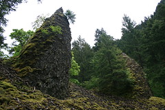
From the Herman Creek Campground, the trail switchbacks uphill, then down to a bridge over the creek at about 1 1/4 miles. A little more than half a mile farther, join the Pacific Crest Trail. Along the PCT, you'll pass smaller creeks, basalt pinnacles and rocky slopes. At about four miles, cross Dry Creek on a bridge, then its a short two-tenths of a mile up a dirt road to a 50-foot waterfall.
Check out the pictures here.
Distance: 8.7 miles round trip.
Trailhead: From Portland, take Interstate 84 about 41 miles east to Cascade Locks. Follow U.S. Highway 30 through Cascade Locks for 1.9 miles, then continue on the frontage road for 1.5 miles to the Herman Creek Campground.
Subscribe to:
Posts (Atom)