December 21, 2009
A country and a continent
View Australia in a larger map
Here's one more look at our trip to Australia last month - through a map. Click the markers for blog entries and photos; if you've been following along, you won't find anything new but will be able to pinpoint our travels.
As you can see, Australia is a big place - a continent, as I've noted before. In two weeks, we covered just this small corner of the country. From Melbourne, at the center of the map, our route took us in a clockwise loop.
With so much more to see, we'll have to go back.
December 9, 2009
Back to the city
After spending the morning at Wilsons Promontory National Park, we made our way back to Melbourne for our last night in Australia. We spent the afternoon taking in a few final sights that we missed when we first arrived.
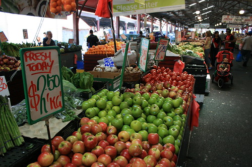
Queen Victoria Market is a massive covered complex just outside the central business district with numerous food stands and merchants selling trinkets, meats and produce. It would have been great to stock up on some fresh fruits and veggies at the start of our trip, but the market was closed the Monday we were in town.
A week and a half earlier, the Melbourne Cup horse race was the talk of the town. Now, the city was decked out for Christmas. (It was still a couple of weeks before Thanksgiving, but Australia doesn't have that holiday, of course.) The big Meyer department store downtown had it's animatronic window display up, decorations were strung high overhead the Bourke Street Mall, and trees and lights could be seen in many shops.
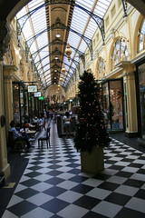
Before dinner, we also walked through the arcades tucked away just off the public mall. We had visited them previously, but all the shops were closed. This time, we were able to look around the stores.
After dinner, it was back to the hotel to pack up and get some sleep before the flight home.
The next morning, we had to hurry out of downtown as a Christmas parade would draw crowds and close streets. Once at the airport, it was only 25 hours to Missoula.
Find photos here.
Queen Victoria Market is a massive covered complex just outside the central business district with numerous food stands and merchants selling trinkets, meats and produce. It would have been great to stock up on some fresh fruits and veggies at the start of our trip, but the market was closed the Monday we were in town.
A week and a half earlier, the Melbourne Cup horse race was the talk of the town. Now, the city was decked out for Christmas. (It was still a couple of weeks before Thanksgiving, but Australia doesn't have that holiday, of course.) The big Meyer department store downtown had it's animatronic window display up, decorations were strung high overhead the Bourke Street Mall, and trees and lights could be seen in many shops.
Before dinner, we also walked through the arcades tucked away just off the public mall. We had visited them previously, but all the shops were closed. This time, we were able to look around the stores.
After dinner, it was back to the hotel to pack up and get some sleep before the flight home.
The next morning, we had to hurry out of downtown as a Christmas parade would draw crowds and close streets. Once at the airport, it was only 25 hours to Missoula.
Find photos here.
Going south
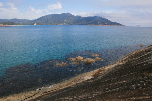
From the mountains, we drove downhill to Wilsons Promontory National Park - or "The Prom" - the southernmost point on mainland Australia.
Unfortunately, in planning our trip this stop was mostly an afterthought; we allotted only one night for our visit because we were trying to break up the drive from Alpine National Park to Melbourne before our departure. In hindsight, it would have been better to spend a full day at The Prom and cut our time in the high country by a day. We'll just have to come back.
Here, the rainforest meets the ocean and the trails are numerous, but we only managed a few short walks.
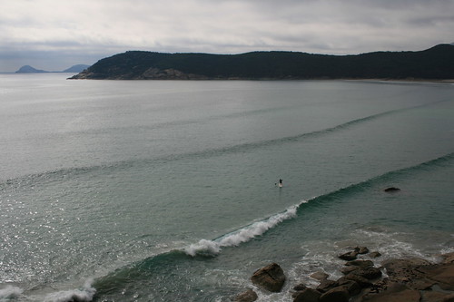
The afternoon we arrived, we set out from the visitor center at Tidal River, hiking around Norman Point to the white-sand beach at Little Oberon Bay. On the way back to our car, we paused on the trail to watch a stand-up paddler surf the waves of Norman Bay with a sweeping backdrop of ocean and islands.
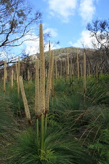
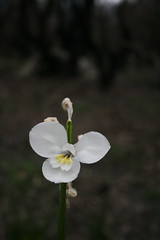
On the way to our cottage outside the park for the night, we took one more quick walk, along the Lilly Pilly Gully track. Orchids were still blooming but past their peak along part of the trail burned by bushfire. And the flowering stalks of grass trees were a unique sight.
With the sun sinking and our stomachs empty, we turned around short. The next morning, we came back to complete the walk through the rainforest, and before leaving we also strolled out to an empty Darby Beach.
From here, it was an easy drive back to Melbourne for one final night in the city.
Pictures from The Prom are here and here.
Norman Point and Little Oberon Bay
This trail wanders through the tea trees to the beach at Norman Bay, then up and around Norman Point, and back down to Little Oberon Bay. About halfway through, a short path detours down to the rocky cliffs on the point. There are plenty of views of surfers and islands.
Distance: 8.2 kilometers round trip.
Trailhead: Start at the visitor center in Tidal River, 29 kilometers south of the park entrance.
Lilly Pilly Gully Nature Walk
Walk through a bushfire area to a short boardwalk loop in the rainforest. The orchids and grass trees are beautiful.
Distance: 5.2 kilometers round trip.
Trailhead: The Lilly Pilly Gully carpark is about 26 3/4 kilometers south of the park entrance.
Darby Beach
A short, sandy walk to a beach where the Darby River meets the ocean.
Distance: 2.2 kilometers round trip.
Trailhead: The Darby River parking area is about 18 kilometers south of the park entrance.
December 7, 2009
Head for the hills
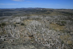
After a long day of driving east from Halls Gap, we arrived in Bright, our entry point to Alpine National Park.
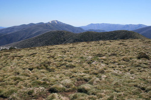
When you hear "Alpine National Park" or "Australian Alps," your first thoughts are likely of tall, pointy peaks. The mountains here, however, aren't that tall or pointy. The highest is Mount Bogong at 1,986 meters, or about 6,516 feet - slightly taller than Mount Dean Stone on the southeast side of Missoula. And the summits are rounded, like many of the mountains around home. This is, however, a popular area for skiing - in fact, we saw some lingering snow on our walks.
I don't mean to belittle these mountains; they can still be a dangerous place, as evidenced by the rescue of a Victorian minister who fell during a snowy September walk to a peak we visited. The region also has been a bushfire hotspot of late, with big burns in 2003 and 2006.
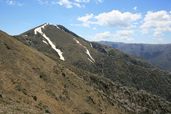
We spent our only full day in Bright driving to the top of the Great Alpine Road and walking out The Razorback to Mount Feathertop. The hike was pretty simple - a long, grassy ridge - but at 22 kilometers round trip, it was the longest and most uncrowded of our vacation. To cap off the full day out in the sun, we stopped at the Bright Brewery back in town to sip down a cool Razor Witbier.
The next day, we spent the morning walking to a couple of waterfalls in nearby Mount Buffalo National Park and the afternoon driving over the Great Alpine Road to Omeo, on the south side of the mountains.
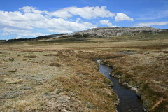
From Omeo, we drove the Bogong High Plains Road - fully paved only a year earlier - up to Falls Creek for a day. Near here, we went on a couple of hikes, including along a short section of the 650-kilometer Australian Alps Walking Track.
After three days in the high country, we next headed for the coast again and Wilsons Promontory National Park, the southernmost part of mainland Australia.
Find all of our pictures here, here and here.
The Razorback to Mount Feathertop
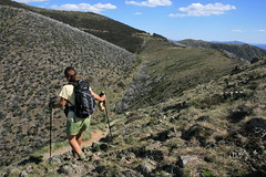
From just below the top of the Great Alpine Road, this trail follows a grassy ridge 11 kilometers out to the top of Mount Feathertop. The majority of the trees along this route were burned in bushfires, and as a result it was a very sunny and hot walk.
Distance: 22 kilometers round trip.
Trailhead: Follow the Great Alpine Road about 49 3/4 kilometers south and east to the pullout for the Diamantina Hut, 2 1/2 kilometers before reaching Mount Hotham. The trail begins across the road from the hut.
Ladies Bath Falls and Eurobin Falls
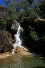
A short trail leads to a couple of picturesque waterfalls. The pool below Ladies Bath Falls is clear, cool and inviting, though we didn't take the time to dip our feet.
Distance: 1.5 kilometers round trip.
Trailhead: From Bright, take the Great Alpine Road 6 1/3 kilometers northwest to Porepunkah, then Mount Buffalo Road 6 kilometers to the Mount Buffalo National Park entrance. Continue about 2 2/3 kilometers to the pullout.
Rollasons Falls
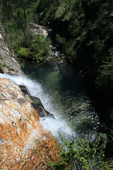
This trail drops down to an upper and lower falls on Buffalo Creek. View the lower falls from the pool below and the upper falls from the drop-off above.
Distance: 2 kilometers round trip.
Trailhead: From Bright, take the Great Alpine Road 6 1/3 kilometers northwest to Porepunkah, then Mount Buffalo Road 6 kilometers to the Mount Buffalo National Park entrance. Continue about 8 3/4 kilometers to the pullout.
Mount Cope
This trail leads up from the grassy plains, through trees to a rocky lookout.
Distance: 3 kilometers round trip.
Trailhead: From Omeo, drive 38 3/4 kilometers northwest on the Omeo Highway. Turn west on the Bogong High Plains Road and follow it about 22 kilometers to the pullout. The path begins across the road.
Australian Alps Walking Track
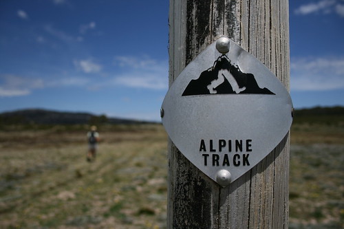
The AAWT is a 650-kilometer route across the mountains from Walhalla in Victoria to Tharwa, near Canberra in the Australian Capital Territory. We walked a short section of it from the Bogong High Plains Road to the Cope Saddle Hut and back. Numbered posts every 40 meters make it easy to follow the trail and calculate your distance.
Distance: 6.7 kilometers round trip.
Trailhead: From Omeo, drive 38 3/4 kilometers northwest on the Omeo Highway. Turn west on the Bogong High Plains Road and follow it about 24 kilometers to the pullout. Our route began across the road.
December 6, 2009
Road rules
The most frequent question we've received since our return from Australia has been some variation of, "Is it difficult driving on the left side of the road?"
The answer: Not really. Australia was, in fact, the second time in the past few years we've had to drive on the left side; we rented a car in Scotland a couple of years ago, too.
Sure, you frequently have to remind yourself that you need to be in the left lane when pulling out of a driveway first thing in the morning - and you may occasionally catch yourself trying to get into the right lane. And yes, the gas and brake pedals are backward.
But once you get going, it's not really that difficult. No matter which side of the road you're on, the driver is always in the middle.
The hardest part, for us at least, was signaling turns. The turn signal and windshield wiper levers are also reversed, and for some reason that tripped us up the most. It also was the hardest thing to readjust to when we returned home and started driving our own car.
The best piece of advice I received about driving on the left side was to rent an automatic. Cars with sticks can be cheaper, but with an automatic it's one less thing to worry about.
Fortunately, because we parked the car in Melbourne and walked or took the tram, we never encountered what appeared would be the biggest obstacle to driving in Australia: the "hook turn" in Melbourne. I won't even try to describe it, so here's a description.
Subscribe to:
Posts (Atom)