I'm officially on the final stretch of training for the Missoula Marathon, having topped out with a 20-mile run this week. And it was quite a wild run.
First, while crossing over the North Hills, I saw that the bitterroots are beginning to bloom (I need to get back up there with my camera). In the residential part of the Rattlesnake Valley, I came across a few deer during their morning munching.
Then, just a mile up the main trail in the Rattlesnake National Recreation Area and eight miles into my run, I rounded a bend and found myself looking at a large bear about 100 feet away - and it was looking back at me.
In the end it wasn't all that big of a deal. I stopped, yelled and clapped at it, it stepped off the path, and I turned around and ran up a different trail. Sure, there's an initial adrenaline rush, but I've encountered bears while hiking before and know the protocols. Mostly, I was thrown off by having to change my route and refigure my mileage - and having to yell "Hey, bear!" - on the run.
As far as the marathon training is concerned, it's going great. I've been able to keep a steady pace on my long runs, and the recovery has gone well.
People have asked me several questions about my big double-digit days: Do I get tired? Not while running; afterward my legs feel like they've had a good workout. Sore? Not really after adjusting to the distance; that's the point of going slow and stretching. That's a lot of energy expended - what about food and water? I take some energy gummies and a hydration pack with me, and yes, it does mean carrying a few extra pounds. What about the final 6.2 miles? My trainer-friend says most marathoners only get up to 20 or 22 miles before the event and think of the last stretch as just another 10K.
I've got a couple of runs in the high teens left, then I taper off until the big day, Sunday, July 12. I'm looking forward to crossing the finish line.
June 13, 2009
June 6, 2009
Red rocks and rain

We recently returned from red-rock country in southern Utah - a place we visit every other year or so. This time, however, we had to change our plans a bit due to heavy rain and lightning.
Originally, we had wanted to camp around Moab and in the San Rafael Swell and hike some slot canyons, but the deluge brought flash floods to the region, and forced us to delay our trip a day and find a hotel room. (On the drive down, I saw a car on a road next to the highway being pummeled by rushing water.)
The night we arrived in Moab, we waited out a storm and took a quick hike in Arches National Park to stretch our legs.
On our only full day in Moab, we managed to get out on a hike in Canyonlands National Park just before another storm rolled in. That evening, the entire town lost power - we ended up cooking dinner on our camp stove in the hotel parking lot.
The next day we drove west, to Zion National Park and Springdale, where the weather was much better and we were able to camp. It rained briefly the first night - just as we were staking down our tent - but the weather the next couple of days was sunny and warm, and we got in two good hikes and a few short walks.
With storms rolling back in, we retreated to Missoula a day early, arriving to a beautiful pink and orange sunset - a sure sign that summer is on the way.
Arches National Park
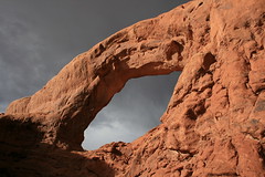
The night we arrived in Moab, we waited out the rain and lightning, then took a quick walk around North Window and South Window arches (above) as the sun was sinking in the sky.
See the pictures here and here.
Distance: 1 -plus-mile loop.
Trailhead: Arches National Park is 5 miles north of Moab, just off U.S. Highway 191. From the entrance, it's 12 miles on park roads to the Windows trailhead.
Canyonlands National Park

In Canyonlands, we hiked the Syncline Loop in the Islands in the Sky district, which drops down 1,300 feet, follows a couple of washes around Upheaval Dome, then climbs back to the trailhead.
The trail provided great views on the descent (top), some canyon hiking, a scramble up through a boulderfield and plenty of desert wildflowers, such as the sego lily (above).
Syncline is one of Backpacker magazine's "Best Dayhikes" - and while the write-up suggested hiking the loop in a clockwise direction, it seemed we were the only ones doing so.
See the pictures here and here.
Distance: 8.5-mile loop.
Trailhead: Canyonlands' Islands in the Sky district is 32 miles north and west of Moab via U.S. Highway 191 and State Route 313. Park at the Upheaval Dome trailhead, which is 11 miles from the visitor center on park roads.
Zion National Park
In Zion, we went on a couple of 8-mile hikes and several much shorter sightseeing walks.
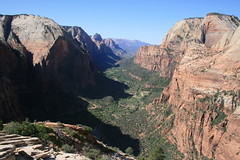
The first full day we were there, we took the West Rim Trail out a ways. About halfway through the hike, we climbed out a narrow ridge - about 3 feet wide at its skinniest - to Angels Landing, a point 1,400 feet above the floor of Zion Canyon with a fabulous view (above). Chains are installed along the ridge for hikers who feel they need to hang on.
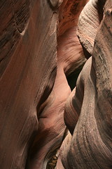
Our second day in the park, we hiked out the East Rim Trail and up to Observation Point, another promontory that looks down on the canyon (and Angels Landing) from 2,100 feet above. At one point, the trail winds through a water-carved slot in Echo Canyon (above).
In all, we figured we walked up at least a couple of hundred switchbacks - we'll be sticking to out-and-back valley hikes for a while, thanks.
See the pictures here and here.
Distance: 8 miles round trip on the West Rim Trail and up to Angels Landing. (Angels Landing alone is 5 miles round trip.) 8 miles round trip to Observation Point.
Trailhead: Spring through fall, Zion Canyon is only accessible via the park shuttle. From the visitor center just inside the park entrance at Springdale, take the bus up the canyon to the Grotto trailhead for the West Rim/Angels Landing, and the Weeping Rock trailhead for the East Rim/Observation Point.
Subscribe to:
Posts (Atom)