Looking at the blog lately, it would appear we've been hiking more outside of Montana than in. The numbers bear that out as a whole, although Montana is the state with the most miles.
Here's our mileage and days on the trail by state since the start of May:
Montana: 37.3 miles over six days
Hawaii: 26 miles, three days
Oregon: 22.4 miles, three days
Utah: 15.8 miles, three days
Note that this also doesn't include dog walks and runs on trails near town.
Last week, we returned to my home state of Oregon for a follow-up gathering to August's wedding and to visit friends who recently moved there. As usual, we took the opportunity to get out, hiking on the Oregon Coast and in the Cascade Mountains.
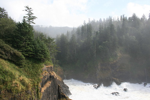
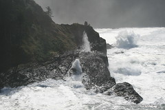
First up was a short trip to Hart's Cove at the Siuslaw National Forest's Cascade Head Scenic Research Area near Lincoln City, an easy drive west from our friends' house in Monmouth. We got a glimpse of the sun through the fog and took in crashing waves and a small waterfall that spills into the sea.
On the way back to Portland from Monmouth, we stopped by Silver Falls State Park in the low Cascades to walk the Trail of Ten Falls. It's similar to the Columbia River Gorge, with water flowing over basalt cliffs.
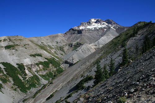
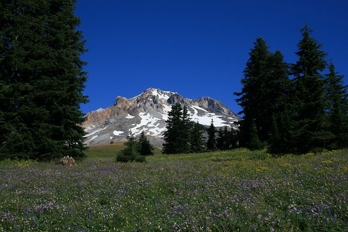
Finally, we took a day to drive up to Timberline Lodge on Mount Hood and hiked a section of the Timberline Trail/Pacific Crest Trail to Paradise Park. The path crosses the Zigzag Canyon to a wildflower-filled meadow that was still in bloom at the end of September.
Thanks go to PortlandHikers.org, which has helped us discover a couple of these and several other adventures in the area.
Oregon Coast: Hart's Cove
While visiting Monmouth, friends suggested going for a hike to Hart's Cove in the Coast Range near Lincoln City, which they had heard about. The next morning, three of us made the drive to the trailhead.
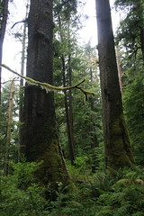
The trail begins by switchbacking down nearly 1,000 feet through a lush Sitka spruce and Western hemlock rainforest. At half a mile, it crosses Cliff Creek and continues generally north.
After crossing Chitwood Creek, the trail leaves the forest at an open headland at 2.7 miles, the destination. From the south side of the headland, the small Chitwood Falls can be seen dropping into Hart's Cove. A trail also leads closer to the water on the west side. All around, waves crash onto the steep, rocky coastline.
We had a bite to eat and played a game of cribbage while the morning fog cleared, then heard and saw sea lions offshore as we started the climb back to the trailhead.
Trailhead: Turn west on the unsigned Forest Road 1861, about 8.75 miles north of Lincoln City on U.S. Highway 101, and follow it about four miles to the end.
Silver Falls State Park: Trail of Ten Falls
The Trail of Ten Falls at Silver Falls State Park, near Salem and Silverton, has a wonderful 8.7-mile trail through lush forest and along creeks that passes nine, 10 or 11 waterfalls along the way - depending on your definition of a waterfall. We broke up our drive back to Portland with a stop to hike. With photos of so many waterfalls, this trip seemed like a good candidate to try Storify's new slideshow feature. Follow along below.
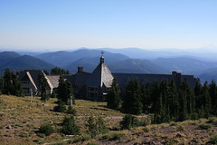
Jen had hiked on Mount Hood on a previous trip but had never been up to the historic Timberline Lodge, so we made a day trip of it from Portland. After a quick look in the hotel, we set out northwest on the Timberline Trail/Pacific Crest Trail.
The path passes behind the lodge and sets out under lifts on ski runs where I learned to downhill as a child. It crosses into the Mount Hood Wilderness and continues gently down through the forest and Little Zigzag Canyon, then past a trail junction. Along the way, the summit of Hood can be seen to the north, and Mount Jefferson and the Three Sisters to the south on clear days.
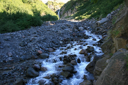
An overlook of the gaping Zigzag Canyon is reached at about 2.2 miles. Here, the view includes the rushing Zigzag River, the rocky Mississippi Head and above it Zigzag Glacier.
The trail then switchbacks steeply down through the trees for a mile to the river. Depending on the water level, the stream can be forded, or scramble across on rocks. Zigzag Falls can be seen a short distance upstream.
Not quite half a mile up out of the canyon, the trail reaches a junction with the 2.6-mile Paradise Park Loop. Here, we turned northeast and continued climbing out of the forest to the junction with the Paradise Park Trail at nearly 4.6 miles, where we found fields filled with blue lupine, purple asters, red paintbrushes and more.
A short distance above the junction, we stopped at a grassy overlook to take in the view, eat and fly a kite before backtracking to Timberline.
Distance: About 9.5 miles round trip. Paradise Park begins about 4.6 miles northwest of Timberline Lodge on Mount Hood, at the junction of the Paradise Park and Paradise Park Loop trails.
Trailhead: Behind Timberline Lodge, three-quarters of a mile east of Government Camp on U.S. Highway 26 and 5.3 miles northeast on Timberline Highway.