For our fall vacation this year, we headed south to Colorado to visit family and check out one of the country's newest national parks:
Great Sand Dunes.
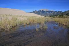
While the park designation became official in 2004, the dunes have been building at the base of the Sangre de Cristo Mountains for thousands, possibly millions, of years, according to the park brochure. Sand from mountains to the west piles up at the foot of the range, carried by strong winds and creeks, creating the tallest dunes in North America.
We've wanted to return ever since passing nearby on the way to New Mexico in 2001. Last week, after 17 hours of driving from Missoula with an overnight in Denver, we spent three days in the dunes.
Day 1: High Dune
The afternoon we arrived we spent asking park rangers about spending a night in the dunefield then getting acclimated.
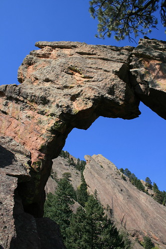
The Great Sand Dunes visitor center sits at about 8,200 feet elevation - almost 5,000 feet above home - so we started with a short hike up High Dune, at 650 feet the second tallest in the park.
Within sight of the visitor center and day-use parking lot, the High Dune route is one of the most popular in the park. And while there were plenty of people in the dry bed of Medano Creek and sledding or boarding down lower dunes, we were on our own when we reached the top.
There are no real trails in the dunes, but the well-trod path was easy to follow. Also, loose sand meant plenty of backsliding, but there were also firmer areas - which offered confidence for the next day, when we would be carrying full backpacks.
See photos from High Dune
here.
Distance: About 3.3 miles round trip.
Trailhead: Visitor center or nearby day-use parking area, 1 mile north of Mosca, Colo., on Highway 17, 16 miles east on Lane 6 and 6 miles northeast on Highway 150.
Days 2 and 3: Backcountry camping in the dunefield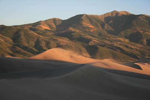
After spending the night in nearby Alamosa, we arrived at the Great Sand Dunes visitor center the next morning and picked up a free backcountry permit to camp in the dunefield.
Up Medano Creek Primitive Road, we parked our car at the Point of No Return trailhead and set out.
The first three-quarters of a mile down to the Sand Pit picnic area on the edge of the dunes is on a trail, but after crossing Medano Creek it's pretty much your choice. The only caveat for backpackers is that you have to get over the first ridge and out of sight of the visitor center. That and you're limited by how much water you can carry, as there is no source once in the dunefield.
Beyond the creek, we wandered up to a low spot on the first ridge and surveyed our options. My GPS having conked out at the trailhead, we also made a few visual references as to the location of Sand Pit and Point of No Return: a large sign between a couple of trees just up from the creek, and a low summit covered in golden aspens in the Sangre de Cristos.
From the first ridge, we connected several meandering crestlines, climbing higher and higher.
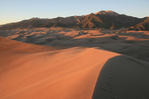
After a few hours of wandering in the sand, we selected a high saddle between two dunes for our campsite. From the saddle, views extended out two valleys, and one of the nearby ridgelines would be a great vantage point at sunset.
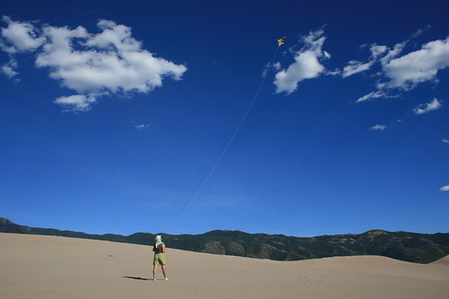
After we set up our tent, Jen assembled a cheap children's kite and let it fly. She brought it figuring there would be a good breeze, and was more than right. As afternoon turned to evening, the wind picked up and streams of sand shot across the dunes, spilling over the crests. For dinner, we took shelter in the tent, but even that didn't keep the grit out of our food.
Eventually, the sun dropped, casting long shadows across the sand. Late at night, the wind died and the stars - away from any city lights - were spectacular.
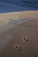
When we woke the next morning, all footprints from the day before were gone - a blank slate for a new day. At some point after the wind settled and we fell asleep, however, we had a visitor of the canine variety, as evidenced by the tracks leading away from the vicinity of our tent.
We packed up and set out after a light breakfast, again following several crestlines, back and forth, up and down. The aspen-covered summit above where we parked was easy enough to see the entire time, so we never felt in danger of getting lost.
Eventually, we made our way to the low spot on the first ridge, back across the creek and up to our car, never seeing another person up close for the entire circuit.
See photos from the dunefield
here.
Distance: As far as you want; we probably trekked a couple of miles in.
Trailhead: Point of No Return, about 2 miles north of the visitor center on Highway 150 and Medano Pass Primitive Road.