November 30, 2009

Rocks and 'roos

grampians_20091106_182

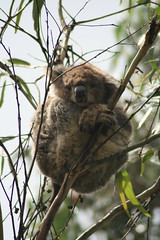
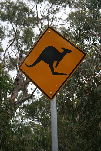
The next leg of our journey through Australia brought us inland to Halls Gap and Grampians National Park, known for its rugged bushwalking, waterfalls and wildflowers. Then there are the kangaroos.

We selected D'Altons Resort as our accommodation in Halls Gap based on the recommendation of Lonely Planet's guide to Australia and the price. Plus, the guidebook mentioned kangaroos and the resort's Web site featured pictures of the animals - both turned out to be accurate.

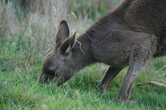
The evening we arrived, we spotted the first kangaroos of our trip, just off our cottage's front porch on the lawn. The next morning, while sipping coffee and looking out the front window, a line of eight bounced up from our driveway, across the grass and into the trees. Like clockwork, they would return every morning and evening.

(Really, you're likely to see kangaroos anywhere you stay in Halls Gap. And cockatoos. They're everywhere.)

That first morning, we had planned a good day of hiking but decided to try our luck with wildlife on a quick walk near the park's visitor center. Sure enough, we saw kangaroos here and there munching grass in the morning sun, as well as a few red deer. We also encountered something we hadn't expected: cold.

In our first few days in the country - the first few days of the month - the TV news had already said it was the warmest November on record since 1925. And it was quite a change from the early cold spell back in Missoula. We thought we'd never need them, but it was a good thing we packed warm coats and gloves - that walk was a chilly one. It quickly warmed up, though, and we hit the trail on the first real hike of our holiday.

grampians_20091106_191

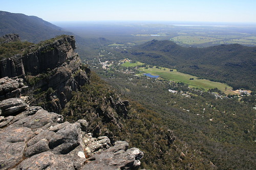
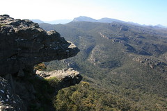
A few hundred meters up the road from our cottage, we set out on the Wonderland Loop. The track follows a creek behind town, then climbs up through rocky mountains before topping out at The Pinnacle, an outcrop above Halls Gap. From there, it descends the face of the mountains back into town. Along the way, we saw plenty of wildflowers remaining from the spring bloom - the result of bushfires throughout the area in 2006. (While there were still plenty of blackened trees, the park appears to be recovering well, with plenty of green growth.)

grampians_20091107_045

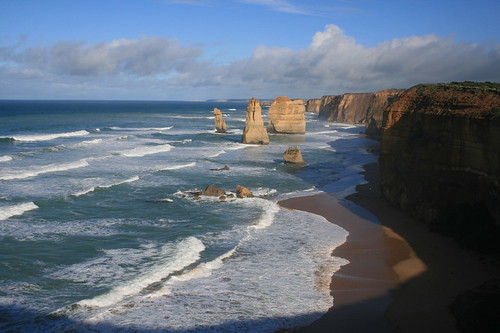
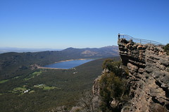
We spent the next day driving around the Grampians and taking shorter strolls to see waterfalls and scenic overlooks. These included The Balconies, MacKenzie Falls, Lake Wartook, Silverband Falls and Mount William.

grampians_20091107_158

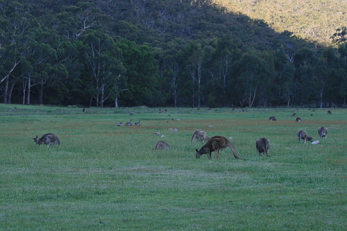
After dinner at the cottage that evening, we decided to check out the trail near the park visitor center again to snap a few more wildlife pictures. We hit the jackpot - a field filled with kangaroos big and small, eating and bouncing around. There were probably a couple of hundred or so, and we lingered for a while to watch.

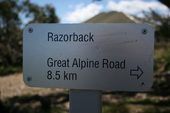
The next morning, we departed early - we had a full day's drive east ahead of us, to Victoria state's high country and Alpine National Park.

See all of our pictures here and here.

Fyans Creek Loop

grampians_20091107_224

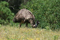
This short loop walk travels through the bush north along the west side of Fyans Creek, crosses a bridge, then travels south to a field, crosses another bridge and returns to the start. See kangaroos and red deer in the morning and evening.

Distance: 2.5-kilometer loop.

Trailhead: The walk begins and ends at Brambuk - The National Park and Cultural Center, off Grampians Tourist Road on the southern edge of Halls Gap.

Wonderland Loop

grampians_20091106_147

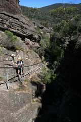
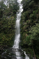
This trail was the highlight of our time in the Grampians. From the parking area, it follows Stony Creek behind town and past the Venus Baths - where the water flows though a series of pools and over smooth rocks - then climbs to Splitters Falls and the Wonderland parking area. Here, it ascends through the narrow-walled Grand Canyon, a great place to find some shade, and past Bridal Veil Falls and Silent Street to The Pinnacle, a lookout above Halls Gap. The trail then descends through the forest on the face of the mountains and back to town. (The only downside to this walk is there are many metal railings and steps that look out of place.)

Distance: 9.6-kilometer loop.

Trailhead: The trail begins and ends in the parking area across Grampians Tourist Road from the shops in Halls Gap.

The Balconies

grampians_20091107_023

This easy walk travels out a rock outcrop with views north to Lake Wartook, then through the forest to a pair of ledges known as The Balconies.

Distance: 2 kilometers round trip.

Trailhead: From Halls Gap, follow Mount Victory Road 12 1/4 kilometers northwest and turn south on the access road. Drive two-thirds of a kilometer to the parking area.
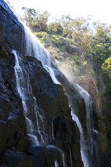
MacKenzie Falls

grampians_20091107_040

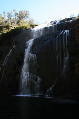
A path leads to overlooks and the base of MacKenzie Falls, a large cascade that, I gather, looks much more impressive when there's more water. (At one time a trail continued to the Zumstein picnic area, but the route was closed after bushfires.)

Distance: 2 kilometers round trip.

Trailhead: From Halls Gap, follow Mount Victory Road 17 1/4 kilometers northwest and turn north on the access road. Turn west at the T intersection and drive a short distance to the parking area.

Silverband Falls

grampians_20091107_054

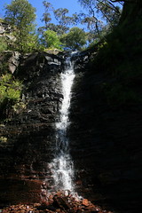
This trail travels through a fern forest to Silverband Falls, which cascades down a wall then disappears underground. We had good luck spotting cockatoos here, as well.

Distance: 1.4 kilometers round trip.

Trailhead: From Halls Gap, follow Mount Victory Road about 5 kilometers west and turn south on Silverband Road. Follow the road about 7 kilometers to the parking area.

Mount William

grampians_20091107_117

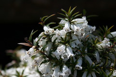
From the parking area, follow the closed road up to the top of 1,167-meter Mount William, the highest point in the Grampians. A lot of wildflowers were in bloom along the road when we visited, and the top provides expansive views west into the park and east out of the park.

Distance: 3.8 kilometers round trip.

Trailhead: From Halls Gap, follow Grampians Tourist Road about 12 1/4 kilometers south, then turn east on Mount William Road and drive about 9 1/2 kilometers east to the parking area.

November 27, 2009

To the beach

port_campbell_20091104_001

After a day in Melbourne, we set out west for the Great Ocean Road and Port Campbell. As you can tell from the pictures, it was a little cloudy with a few spots of sun. It was cool and rained a few times, but not really that bad.

The first stop on our journey was Split Point Lighthouse and Eagle Rock Marine Sanctuary at Aireys Inlet, where we stretched our legs with a short stroll down to the beach.

After that it was on to Lorne, where we took in views of the Great Ocean Road from Teddy's Lookout and went on a quick walk to Erskine Falls in Great Otway National Park.

kennett_river_20091103_035

From Lorne, we followed the winding coastal route through Apollo Bay to Kennett River, where we got our first glimpse of Australian wildlife. On a recommendation, we walked a short distance up Grey River Road, spotting koalas napping in the branches of gum trees.

We continued on, driving up through the tree-covered hillsides and back down to the coast before reaching Port Campbell, our base for the next couple of days. Here, we would take in Port Campbell National Park, the site of numerous scenic sea stacks up to 70 meters tall.

tower_hill_20091105_067

On the way to our next destination, we stopped at Bay of Islands Coastal Park to see more sea stacks and arches, and at Tower Hill State Game Reserve, just off the Great Ocean Road near Warrnambool, where we walked around an old volcanic crater and saw numerous emus.

The next leg of our journey would take us inland to Halls Gap and Grampians National Park, where the weather would heat up and the kangaroos would abound.

See pictures here and here.

Erskine Falls

erskine_falls_20091103_013

Follow the fern-lined trail and steps down to the base of Erskine Falls, one of many waterfalls near Lorne.

Distance: 700 meters round trip. (There's also a 15-kilometer round trip trail from Lorne to Erskine Falls.)

Trailhead: From Lorne, follow William Street and Erskine Falls Road about 8 1/2 kilometers out of town. Turn right and follow the access road about 1 1/2 kilometers downhill to the trailhead.

Twelve Apostles

port_campbell_20091104_024

A path leads under the highway and out a boardwalk to overlooks of the Twelve Apostles, limestone sea stacks off the coast at Port Campbell National Park.

Distance: 1 kilometer round trip.

Trailhead: Follow the Great Ocean Road 10 3/4 kilometers east of Port Campbell to the Twelve Apostles Visitor Centre.

Loch Ard Gorge

port_campbell_20091104_083

More sea stacks, as well as access to the beach below the cliffs, the Blowhole, Thunder Cave and Broken Head.

Distance: Three trails range from 900 meters to 3 1/4 kilometers round trip.

Trailhead: Follow the Great Ocean Road 7 1/4 kilometers east of Port Campbell to the parking area.

Gibson Steps

port_campbell_20091104_067

Steps were carved down the limestone cliffs to the beach in the 19th century. They're concrete now.

Distance: Unknown; negligible.

Trailhead: Follow the Great Ocean Road 11 3/4 kilometers east of Port Campbell to the parking area.

The Arch

port_campbell_20091105_007

The Arch is pretty self-explanatory - an arch from the cliffs to the sea.

Distance: 280 meters round trip.

Trailhead: The Arch is 6 kilometers west of Port Campbell on the Great Ocean Road.

London Bridge

port_campbell_20091105_013

London Bridge used to be a double arch, but one side collapsed.

Distance: 200 meters round trip.

Trailhead: London Bridge is 7 kilometers west of Port Campbell on the Great Ocean Road.

The Grotto

port_campbell_20091105_023

The Grotto is another arch, up off the ocean.

Distance: 680 meters round trip.

Trailhead: The Grotto is 8 2/3 kilometers west of Port Campbell on the Great Ocean Road.

Bay of Islands

bay_of_islands_20091105_018

Bay of Islands has numerous sea stacks and arches.

Distance: 1.8 kilometers round trip.

Trailhead: Bay of Islands is 17 3/4 kilometers west of Port Campbell on the Great Ocean Road.

Tower Hill Reserve

tower_hill_20091105_033

Tower Hill is a volcanic formation believed to have last erupted 32,000 years ago. Today, there are a handful of trails through and around old craters. We walked up and around a crater and saw several emus.

Distance: Unknown; probably a few kilometers.

Trailhead: From Warrnambool, follow the Princes Highway 12 kilometers west then turn north on the entrance road and take it 1 1/2 kilometers to the Worn Gundidj Visitor Centre.

November 20, 2009

Melbourne bound

melbourne_20091102_079

Our starting and ending point for our trip to Australia was the metropolis of Melbourne, which sits on the country's southern coast where the Yarra River lets out into Port Phillip Bay. The city itself has a population of just 90,000; including its 11 suburbs, that figure jumps to 3.9 million. Settled by Europeans in 1835, it is the capitol of Victoria state and Australia's second-largest city.

Why Melbourne? We bought our plane tickets during a fare sale on flights to Sydney and Melbourne. While Sydney has its famous opera house and bridge, we're not really city folk, as you can probably tell from this blog. On the recommendation of an extended family member from the area, we chose Melbourne for its access to national parks and bushwalking in the region.

After 31 hours of travel from Missoula - including a nine-hour layover in Denver - we arrived in Australia just after 10 a.m. Crossing the International Date Line jumped us ahead a day, but it went pretty smoothly, as I slept through most of the nearly 15-hour leg from Los Angeles to Sydney. (Australian airports are a little odd, though. It's almost as if you're funneled through a department store of duty-free items between your gate and customs.)

After touching down, we located our rental car - apparently Alamo isn't Alamo at the Melbourne airport; it's Europcar - and made our way to our hotel downtown. Once we were checked in and cleaned up, our adventure began.

melbourne_20091102_066

We spent our first afternoon getting oriented. Leaving the car behind, we bought tram tickets and a map. Downtown is a decent size but still very walkable, and the tram system makes it even more so. We made our way into the center of town, checking out City Square, Federation Square and the Yarra riverbank; looking in a few stores; and reading a few menus along the way. After some dinner at a local watering hole, we called it a night.

Melbourne has a heavy British influence - especially in some of the older buildings - as well as an Asian and Middle Eastern presence due to Australia's location on the globe. But I was surprised at how American it was downtown, mostly when it came to the retailers. McDonald's, Hungry Jacks (Burger King), Subway, Target. Granted, you probably won't find a foot-long chicken tikka sandwich in the United States.

Architecturally, the city has an old-meets-new feel: the spires of St. Paul's Cathedral across the street from the jaunty, metallic buildings on the edge of Federation Square; the Flinders Street Station dome vs. the modern, wavy roof of Southern Cross Station.

And Melbourne is a busy place, the trams and sidewalks packed with people during the workday. It doesn't let up after quitting time; people crowd the city's many cafes, restaurants and pubs, spilling out into sidewalk seating.

melbourne_20091102_002

The next day, we set out early, starting with breakfast at a cafe around the corner from the hotel. Next, we hopped the tram up to the top of downtown and the Parliament House of Victoria. From there, we walked back down to the center of the city through Chinatown. We passed ornate archways at the start of each block, as well as a lot of food pictures and even some Peking ducks hanging in restaurant windows.

As we walked back toward Federation Square, we noticed people putting up barriers along one of the main streets. A worker told us a parade would be held in a couple of hours for the Melbourne Cup horse race, so we decided to return later. In the meantime, we took a relatively quiet stroll through the Royal Botanic Gardens on the other side of the Yarra, checking out the flowers.

melbourne_20091102_108

Back downtown, the crowd near Flinders Street Station had swelled with people from nearby office buildings as well as anti-horse-jumping protesters. The parade took place uninterrupted and featured past champion horses, current jockeys and other celebrities - think Olivia Newton John. As soon as the festivities were over, people clogged the streets on their way back to work.

melbourne_20091102_094

After lunch, we wandered a bit more, then took the free tram that loops downtown, traveling out to the to the high-rises of the formerly industrial Docklands and back up to Parliament. Next, we found our way to St. Paul's Cathedral for a look inside at its stained-glass windows and alternating rows of light and dark stonework.

After a quick trip back to the hotel to clean up, we grabbed some dinner at the James Squire brewery in the Portland Hotel, then picked up some groceries and turned in early for the night. The next day, we would set out on the Great Ocean Road west of Melbourne.

Find more pictures from Melbourne here and here.

November 15, 2009

Up from Down Under

teddys_lookout_20091103_004

We're fresh back from two weeks in Australia, and in the interest of getting something posted fairly quickly I'm starting with some numerical odds and ends from our visit.

18,912: miles flown round trip from Missoula to Melbourne, with layovers in Denver, Los Angeles and Sydney. The longest leg was about 15 hours from L.A. to Sydney.

Oct. 31:
Halloween, the day we didn't really see because of crossing the International Date Line. (We did get to carve pumpkins with our niece and nephew in the Denver area during a long layover on Oct. 30.)

Nov. 14:
the day that seemed double, again due to crossing the International Date Line.

17:
number of hours Melbourne is ahead of Missoula.

92:
value of the American dollar in Australian cents at the time of our trip. We came out ahead even with foreign exchange and ATM fees.

One:
the number of Australian states we visited - Victoria. Hey, it's a big country. A continent, in fact.

Six:
the number of cities and towns we stayed in - Melbourne, Port Campbell, Halls Gap, Bright, Omeo and Yanakie.

halls_gap_20091105_002

2,702: kilometers driven in our rental car. That's about 1,679 miles.

1.20:
rough estimate of the average price we paid per liter of gas in Australian dollars. Equals about $4.18 per gallon in U.S. dollars. It cost more than $45 Australian to fill up.

6.80:
price for a full-day tram ticket for Melbourne's central business district in Australian dollars. Downtown is extremely walkable, made even more so by the trams.

60, 80, 100 and 110:
the most common speed limits we encountered, in kilometers per hour (about 37, 50, 62 and 68 in miles per hour). Sixty was normal in urban areas (occasionally it was 40 or 50 kph), 80 entering and leaving urban areas, 100 on most highways, and 110 on freeways.

Six:
also the number of national parks we visited - Great Otway, Port Campbell, Grampians, Alpine, Mount Buffalo and Wilsons Promontory.

alpine_20091109_033

85: low estimate of the kilometers we walked in the bush; couldn't find distances for a few walks. That's almost 53 miles. Our longest outing was the 22K (13.7-mile) round trip out The Razorback to Mount Feathertop and back.

Four:
number of mountains we walked up - The Pinnacle, Mount William, Feathertop and Mount Cope.

26 and 12:
average high and low temperatures for our time in Victoria in Celsius (about 79 and 53 in Fahrenheit). By comparison, the high and low temperatures the day we returned to Missoula were 36 and 22 Fahrenheit (about 2 and minus 6 in Celsius).

30 and 70:
SPF of sunscreens we wore. Still got probably the best tan of my life.

One:
also the number of bushfires burning in areas we visited. Saw smoke from The Razorback.

kennett_river_20091103_113

Five: the number of koalas we saw. Also saw a handful of emus, wallabies, kookaburras and rosellas, and too many kangaroos and cockatoos to count.

melbourne_20091103_003

Two: the number of AC/DC references we saw in Melbourne - ACDC Lane and a poster of Angus Young advertising an art exhibit we never found.

Six:
also the number of microbreweries we visited - James Squire in Melbourne, Flying Horse in Warrnambool, Halls Gap Brewery in Halls Gap, Tooborac Hotel and Brewery in Tooborac, Bright Brewery in Bright and Grand Ridge in Mirboo North. (Victoria is home to 35 of Australia's 120 microbreweries, according to "The Beer Lover's Guide to Victoria's Microbreweries.") Bright's Razor Witbier hit the spot after walking The Razorback out to Mount Feathertop. Six is also the number of bottles of craft beer that made it home to Missoula in our checked bags without breaking.

One:
also the number of distilleries visited - Timboon Railway Shed in Timboon. Tasted five liqueurs. The Nocino green walnut-based liqueur is delicious.

One:
also the number of wineries we visited - Heytesbury Ridge outside of Timboon. Tasted four wines.

One:
also the number of cheesemakers we visited - Apostle Whey in Cooriemungle. Tasted 14 cheeses.

Zero:
meat pies or pasties eaten. Sorry, vegetarians here. The vegetable roll at the High Plains Bakery in Omeo was great, though.

Of course, there was much more to our holiday than this, and more posts will be coming.