Where can you see Montana, Idaho, Oregon and Illinois - Illinois? - on the same dayhike? On the Stateline Trail, southwest of Superior.
In the five miles southeast of Cascade Pass, Montana and Idaho make up the ridge that the trail tracks, then there are the Oregon Lakes and Oregon Peak, and Illinois Peak.
There are a variety of access points to the Stateline Trail, Cascade Pass being a relatively easy, but long approach. It's about 25 bumpy, dusty miles by car from Superior. On Tuesday, my dog Belle and I had the trail to ourselves - only one other vehicle was in the parking area, but we never saw anyone else.
From the pass, I've been northwest to Bonanza Lakes before, but this was the first time I've headed southeast to Illinois Peak.
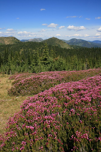
The route is mostly open, grassy forest with gentle ups and downs. In fact, the terrain bears a resemblance to hiking in Scotland or the Australian Alps, especially with the abundant pink mountain heather, top. I was also quite surprised by the variety of wildflowers in bloom - bluebells, a few varieties of penstemon, bracted lousewort, purple shooting stars, heather, yellow pasqueflower, mountain gentian, phlox and more.
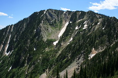
At about 1 3/4 miles, the path passes above the uppermost of the three Oregon Lakes, with its deep blue water. The trail steepens at four miles and climbs through some interesting rocks - look for the ripples of old seabed. At about 4 1/2 miles, take the east fork through two junctions, then it's up the final push to the grassy summit of the 7,690-foot mountain.
A great start to a week of vacation!
Here are some photos.
Distance: 10 miles round trip.
Trailhead: From Superior, follow Diamond Match Road on the west side of Interstate 90 about 1 1/4 miles southeast, then Cedar Creek Road (Forest Road 320) 25 miles southwest to Cascade Pass.