
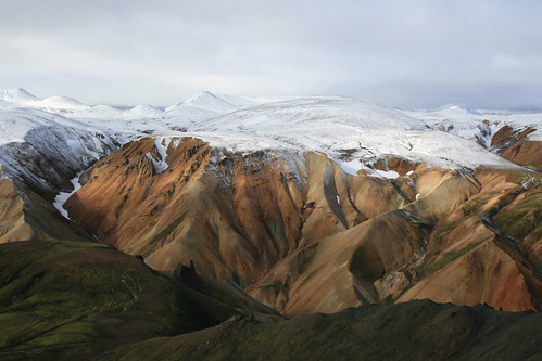
Our first stopover in Iceland - and the place where we would spend the most time - was Fjallabak Nature Reserve, where trails climb into the rhyolite hills from the Landmannalaugar Hut.
Our intention was to backpack part of the well-known Laugavegur trail south to the Hrafntinnusker Hut, spend the night, then return to Landmannalaugar. However, when trying to reserve bunks in the huts in Reykjavík, we found Hrafntinnusker full. Instead, we stayed at Landmannalaugar for three nights and dayhiked in the area.
Getting to Landmannalaugar is a small adventure in and of itself. On the way that morning, we stopped at Geysir and Gullfoss to see the thermal area and waterfall. From there, we followed mostly paved roads south and east to connect with the main route into Fjallabak - the F208.
Iceland's F roads are mountain routes, similar to our forest roads. While some of these roads likely are passable in a two-wheel-drive vehicle, rental car companies will only allow four-wheel-drives on them - there are many signs, brochures and stickers warning of this - due to extreme terrain and river crossings.
The northwest segment of the F208, which we drove, is one of the more tame F roads, mostly being rocky and washboarded. At Landmannalaugar, however, you have a choice: About 200 meters before the hut, the road crosses two braids of a river with parking on each side. After stopping short, thinking we would walk our gear across a footbridge to the hut, we watched a couple of vehicles cross the stream and decided instead to ford it. It ended up being simpler than I thought, and even easier on the way out.

At the hut, we were assigned a room on the second floor with several bunks with sleeping pads. Lucky for us, only two other people were in the same room the first night, so we all could spread out our packs and sleeping bags. Unluckily, the room was full and noisy the second night. The last night was better with only four other people. The kitchen, on the main floor, was clean and well-stocked with pots, pans, dishes and utensils, and had several cooking stations. A separate washroom was equally spacious, with sinks in a common area and separate stalls for men and women. Several makeshift laundry lines were strung up by people drying swimwear after having soaked in the nearby hot springs-fed creek.
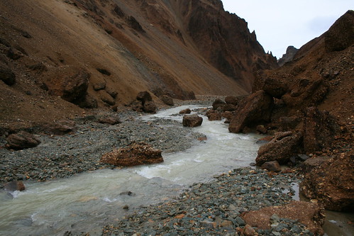
The afternoon we arrived was pleasant and we went on a short walk through a lava field. The second day, however, it rained nonstop. Even so, we trekked up a drainage, crossing a stream several times, until reaching snow blocking the end of it. The third day was partly sunny with a strong wind and fresh snow higher up. Still, we hiked over one mountain, up to a plateau then back over another mountain.
The next day, as we drove back to the Ring Road, we were forced to pull aside for about 1 1/2 hours to let a 22-car rally race pass on the F208. Once back on the main road, we went east across the sandar - glacial sand plains - to Skaftafell, at Vatnajökull National Park.
The following are our Landmannalaugar-based hikes. We bought a copy of "The Laugavegur Hiking Trail," published by Ferðafélag Íslands (the Iceland Touring Association), which contains a basic map and information on trails in the Landmannalaugar area. Unfortunately, it doesn't include distances.
Day 1: Grænagil and Laugahraun
We arrived at the Landmannalaugar Hut late in the afternoon, and after checking in there still was time for a short walk before dinner.
Hiking a short distance south of the hut, we turned southwest into Grænagil, the Green Ravine, named for the color of rhyolite found in the canyon. Here, the trail follows a stream between the Laugahraun lava field and the north flank of the mountain Bláhnúkur.
Soon, the trail leaves the water's edge and turns up into the lava field, where obsidian and patches of moss can be found. The rock is mostly stable, but likely would be painful to fall on. Colored stakes mark the route as it climbs partway up the mountain Brennisteinsalda and leaves the lava.
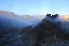
The trail from Grænagil connects with the Laugavegur trail at a steaming outcrop on the multicolored side of Brennisteinsalda. Turning north, we descended along the edge of the lava field to an open valley with the mountain Suðurnámur on the opposite side.
We finished the loop by turning east back through the lava and hiking down to Landmannalaugar.
Here are more photos from Grænagil and Laugahraun.
Day 2: Brandsgil
A downpour the second day at Landmannalaugar didn't deter our desire to go hiking, so we put on our rain gear and set out for Brandsgil on the advice of the guidebook - "ideal if there is a limited view of the mountains."
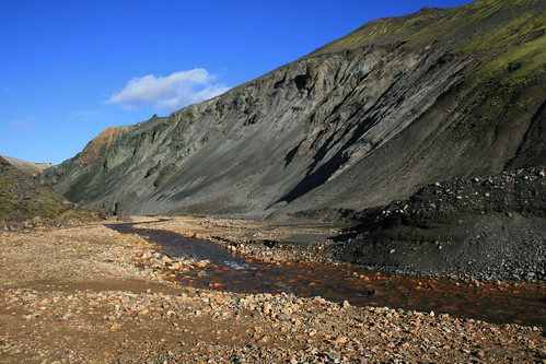
Walking south from the hut again, we passed Grænagil and continued along the flank of Bláhnúkur into Brandsgil, a deep but flat-bottomed canyon with a river flowing through it.

We followed the river up the canyon as it narrowed, crossing the stream several times and taking in the surrounding mountains and rock spires.
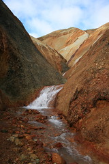
Near the end of the canyon, we reached a large snowfield that appeared impassable, although the guide notes a waterfall just beyond if you feel like scrambling. With the rain nonstop, we turned around and went back to the hut.
Here are more photos from Brandsgil.
Day 3: Bláhnúkur and Brennisteinsalda
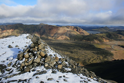
We awoke the third day to see snow high on the surrounding mountains, but only partly cloudy skies and a breeze. The decent conditions allowed us to go on our longest hike while at Landmannalaugar.
South of the hut and just past Grænagil, we switchbacked south up the obsidian-black ridge of 945-meter-tall Bláhnúkur. With a strong wind blowing and a dusting of snow at the summit, we hunkered down for a few photos next to a round metal viewfinder that describes the surrounding mountains.
Over the top, we quickly descended west into Grænagil, crossing the stream at the bottom. Here, we briefly detoured to the south to a spot where a side channel spilled out of a narrow orange canyon. Retracing our steps, we joined the Grænagil trail and made our way to the steaming outcrop partway up Brennisteinsalda.
At the Laugavegur trail, we climbed southwest up the flank of Brennisteinsalda and continued on the path toward the Hrafntinnusker Hut. After reaching snow, we paused at a high point on the plateau to take in the view then turned around.
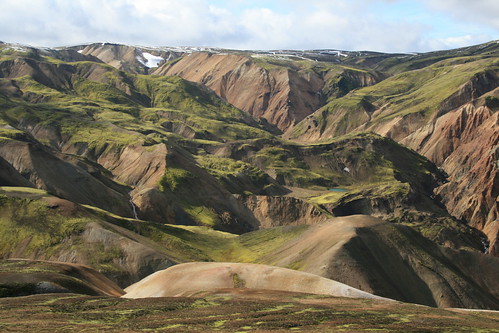
When the trail returned to the flank of Brennisteinsalda, we followed a route north to its 881-meter summit. Seeing the Vondugil below - as it went from wide and flat on the east end to narrow at the west - we descended the trail into the canyon.
At the bottom of Brennisteinsalda, the wind subsided and we crossed the valley floor, past a stream and pond, back to the Laugavegur trail. From here, it was a short walk back over the Laugahraun lava field to Landmannalaugar.
Having been out all day, we ended with a soak in the hot-springs fed creek.
Here are more photos from Bláhnúkur and Brennisteinsalda.
Location: From the Ring Road just northwest of Hella, the Landmannalaugar Hut at Fjallabak Nature Reserve is 82 kilometers northeast on Route 26/F26, 26 km south on F208 and 2 km southwest on F224.