After a long day of driving east from Halls Gap, we arrived in Bright, our entry point to Alpine National Park.
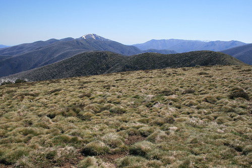
When you hear "Alpine National Park" or "Australian Alps," your first thoughts are likely of tall, pointy peaks. The mountains here, however, aren't that tall or pointy. The highest is Mount Bogong at 1,986 meters, or about 6,516 feet - slightly taller than Mount Dean Stone on the southeast side of Missoula. And the summits are rounded, like many of the mountains around home. This is, however, a popular area for skiing - in fact, we saw some lingering snow on our walks.
I don't mean to belittle these mountains; they can still be a dangerous place, as evidenced by the rescue of a Victorian minister who fell during a snowy September walk to a peak we visited. The region also has been a bushfire hotspot of late, with big burns in 2003 and 2006.
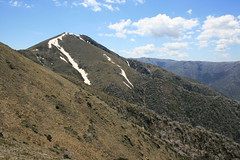
We spent our only full day in Bright driving to the top of the Great Alpine Road and walking out The Razorback to Mount Feathertop. The hike was pretty simple - a long, grassy ridge - but at 22 kilometers round trip, it was the longest and most uncrowded of our vacation. To cap off the full day out in the sun, we stopped at the Bright Brewery back in town to sip down a cool Razor Witbier.
The next day, we spent the morning walking to a couple of waterfalls in nearby Mount Buffalo National Park and the afternoon driving over the Great Alpine Road to Omeo, on the south side of the mountains.
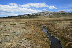
From Omeo, we drove the Bogong High Plains Road - fully paved only a year earlier - up to Falls Creek for a day. Near here, we went on a couple of hikes, including along a short section of the 650-kilometer Australian Alps Walking Track.
After three days in the high country, we next headed for the coast again and Wilsons Promontory National Park, the southernmost part of mainland Australia.
Find all of our pictures here, here and here.
The Razorback to Mount Feathertop
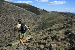
From just below the top of the Great Alpine Road, this trail follows a grassy ridge 11 kilometers out to the top of Mount Feathertop. The majority of the trees along this route were burned in bushfires, and as a result it was a very sunny and hot walk.
Distance: 22 kilometers round trip.
Trailhead: Follow the Great Alpine Road about 49 3/4 kilometers south and east to the pullout for the Diamantina Hut, 2 1/2 kilometers before reaching Mount Hotham. The trail begins across the road from the hut.
Ladies Bath Falls and Eurobin Falls
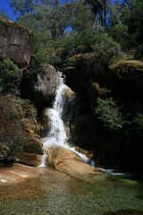
A short trail leads to a couple of picturesque waterfalls. The pool below Ladies Bath Falls is clear, cool and inviting, though we didn't take the time to dip our feet.
Distance: 1.5 kilometers round trip.
Trailhead: From Bright, take the Great Alpine Road 6 1/3 kilometers northwest to Porepunkah, then Mount Buffalo Road 6 kilometers to the Mount Buffalo National Park entrance. Continue about 2 2/3 kilometers to the pullout.
Rollasons Falls
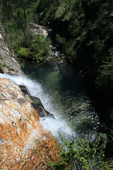
This trail drops down to an upper and lower falls on Buffalo Creek. View the lower falls from the pool below and the upper falls from the drop-off above.
Distance: 2 kilometers round trip.
Trailhead: From Bright, take the Great Alpine Road 6 1/3 kilometers northwest to Porepunkah, then Mount Buffalo Road 6 kilometers to the Mount Buffalo National Park entrance. Continue about 8 3/4 kilometers to the pullout.
Mount Cope
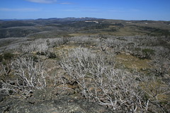
This trail leads up from the grassy plains, through trees to a rocky lookout.
Distance: 3 kilometers round trip.
Trailhead: From Omeo, drive 38 3/4 kilometers northwest on the Omeo Highway. Turn west on the Bogong High Plains Road and follow it about 22 kilometers to the pullout. The path begins across the road.
Australian Alps Walking Track
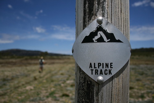
The AAWT is a 650-kilometer route across the mountains from Walhalla in Victoria to Tharwa, near Canberra in the Australian Capital Territory. We walked a short section of it from the Bogong High Plains Road to the Cope Saddle Hut and back. Numbered posts every 40 meters make it easy to follow the trail and calculate your distance.
Distance: 6.7 kilometers round trip.
Trailhead: From Omeo, drive 38 3/4 kilometers northwest on the Omeo Highway. Turn west on the Bogong High Plains Road and follow it about 24 kilometers to the pullout. Our route began across the road.