Seven months ago, Jen and I bought permits to hike up Mount St. Helens in southern Washington on Labor Day. Little did we know it would be raining all weekend. Fortunately, there were still permits available for the next day and the forecast was for clear skies.
After spending the long weekend waiting out the weather with relatives in Portland, Ore., we rose early on the morning of our hike and drove to Cougar, Wash., to pick up our permits and sign the register at the Lone Fir Resort. From there it was a quick drive to the trailhead at Climbers Bivouac.
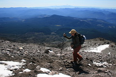
The route up Mount St. Helens is fairly steep, ascending about 4,500 feet in five miles. The first two miles are on a shady trail that rises about 1,000 feet through the forest to timberline. Once out of the woods, the real work begins as the hike climbs 3,500 feet over three miles to the crater rim. The trail fades and becomes rough as you scramble Monitor Ridge's boulder fields, following wooden posts about two miles and 2,200 feet up. The final mile and 1,300 feet of elevation gain are through loose pumice, ash and, in our case, snow from the previous days' storms. The powder wasn't much of a problem - there was only a few inches and earlier hikers had pretty much cleared a path to the crater rim.
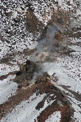
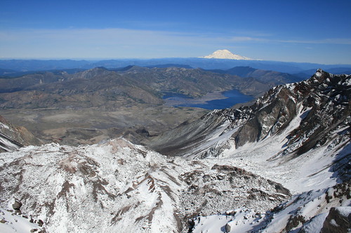
From the rim, you look about 2,000 feet down on the steaming lava dome. To the north are Spirit Lake and Mount Rainier. The peaks of North Cascades National Park stand to the northeast, Mount Adams to the east and Mount Hood to the south.
After spending about 45 minutes at the top snapping pictures and eating lunch, we made our way down. The descent went much quicker, as it was easier to navigate the boulders by looking down from above. After returning to Cougar to sign out, we sped back to Portland, arriving in time for dinner.
Permits are required year-round for hiking above 4,800 feet on Mount St. Helens; only 100 are issued each day from May 15 to Oct. 31. The Mount St. Helens Institute has more information, including the fee structure. Check permit availability here.
See pictures from our trip here and here.
Distance: About 10 miles round trip.
Trailhead: Climbers Bivouac is about 14 miles northeast of Cougar, Wash. Drive about 6 1/2 miles east of Cougar on Highway 503 and Forest Road 90. Turn northwest on Forest Road 83 and follow it about three miles to Forest Road 81. Turn northwest on FR81 and drive two miles. Turn northeast on Forest Road 830 and continue 2 1/2 miles to the trailhead. All but the final 2 1/2 miles are paved.