Showing posts with label Clearwater National Forest. Show all posts

September 3, 2014

On the Stateline above Heart, Pearl lakes

heart_pearl_stateline_2014-08-17_126

I've lost count of the number of times we've been to Heart and Pearl lakes near Superior over the years, but one thing we had never done until recently was hike the portion of the Stateline Trail between the two.

We began by climbing Trail 171 south gradually along the east side of Trout Creek for about 2 miles, then switching back up the side of the valley and turning west to a junction at about 2 3/4 miles, crossing a few streams along the way.

At the junction, we continued west on switchbacks above Heart Lake into a high meadow that held the bare stalks of what must have been a beautiful beargrass bloom a month earlier. The trail then switchbacked up to the ridge that forms the border with Idaho and the junction with the Stateline Trail - Trail 738 - at about 4 1/3 miles. Here, we stopped to eat and saw the first of a handful of mountain goats in the distance along the rocky ridge.
heart_pearl_stateline_2014-08-17_101

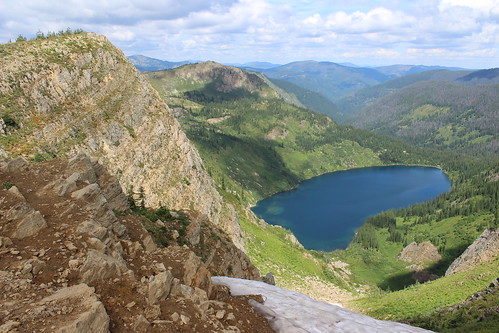
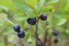
The Stateline followed the ridge southeast, passing a rocky point at 4 3/4 miles and a chute still holding snow at 5 3/4, both providing views of the lakes below. Along the way, we found plenty of huckleberry bushes filled with juicy, tart fruit.

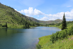
At about 6 miles, we left the Stateline at a junction with Trail 620 and dropped northeast to a saddle between Pearl and Dalton lakes. From there, we continued down Trail 175 and back west around Pearl Lake to its outlet at about 7 1/2 miles, then down again and north to the first junction below Heart Lake at 8 2/3 miles, letting the dogs swim multiple times along the way.
heart_pearl_stateline_2014-08-17_157

After that, we retraced Trail 171 back east and north 2 3/4 miles to our vehicle.

See more photos from Heart and Pearl lakes.

Distance: 11 1/2 mile loop.

Trailhead: From Superior, follow Diamond Match Road southeast and Trout Creek Road southwest - one turns into the other - for 19 miles.

July 1, 2012

13.1 miles to wildflowers in Idaho

packer_meadows_20120630_041

Saturday saw us at Lolo Pass, off U.S. Highway 12 along the Montana-Idaho border, for two reasons: I was running the Mountain to Meadow Half Marathon, and camas flowers were blooming in Packer Meadows.

Every year in late June, the meadows fill with blue flowers, and the run passes by the fields and is usually around the peak bloom - fitting two of my interests.

The run on forest roads just inside Idaho went well and might have been one of my best half marathon finishes, although it should come with an asterisk. The last time I ran the race, it was two weeks before the Missoula Marathon, making it ideal for a final long run before tapering. This year, it was just one week before the marathon, likely limiting the field. Nonetheless, I finished in 1 hour, 50 minutes and 13 seconds, about 8 1/2 minutes faster than my previous best on the course. The time was good enough for 21st overall, 15th among men and fifth in my category.

After the race, we took a stroll about a mile back down the road to the meadows for some photos of the flowers. The bloom was about at its peak last Wednesday, according to the Lolo Pass Visitor Center's Facebook page. Although they were beginning to wilt, the blue blooms still were plentiful.

Here are a few more views of the flowers.

January 14, 2012

New Year's snowshoe at Lolo Pass

lolo_pass_20120101_025

After a busy - and somewhat sad - holiday season, we sought to start off the new year right on a short snowshoe adventure with friends at Lolo Pass on the Montana-Idaho border.

Despite cloudy skies, we had a good day making first tracks in a small amount of powder and going sledding back at the Lolo Pass Visitor Center.

Follow the snowshoe trail up the hill to the south of the visitor center and past a junction. At the top, the trail continues out a ridge that offers good views into Idaho then down a powder-filled slope, crossing a groomed road before reaching Pack Creek. The trail follows along the creek then a cross-country ski trail, and loops back to the junction near the start.

lolo_pass_20120101_048

See more photos from Lolo Pass here.

Distance: About 3 miles.

Trailhead: From Missoula, drive 9 miles south on U.S. Highway 93 to Lolo, then 32 miles west on U.S. Highway 12 to the Lolo Pass Visitor Center, just over the border in Idaho. (Parking costs $5.)

January 8, 2010

Skiing in the new year

lolo_pass_20100103_029

It's been pretty brown in town this winter - the leaves never fully fell, and it seems like there's been more deep freeze than snowfall. Cross-country ski season began last weekend, however, with our annual New Year's outing.

Originally, I wanted to go to the new Como Trails Cross Country Ski Area south of Hamilton, where dogs are allowed. After reading on the Missoula Nordic Ski Club site about having to hike up to snow, though, we settled on a trip up Lolo Pass without the pups.

The day started out with a handful of vehicles in the parking area and the trails shrouded in fog, but after 6 3/4 miles of skiing the sun was out and the lot was packed.

See some photos here.

Distance: Trails from 1.2 to 14 miles are available; some are shared with snowmobiles. We did a 6 3/4-mile loop that incorporated parts of the Glade Creek and Packer Meadows trails.

Trailhead: From Missoula, drive 9 miles south on U.S. Highway 93 to Lolo, then 32 miles west on U.S. Highway 12 to the Lolo Pass Visitor Center, just over the border in Idaho. (Parking costs $5.)

July 1, 2009

Time to taper

mountain_to_meadow_20090627_001

After more than three months steadily increasing my mileage while training for the Missoula Marathon, I'm down to the last two weeks and the "taper."

I closed out my long runs over the weekend with a last-minute entry in the Mountain to Meadow half marathon on dirt roads just across the border in Idaho's Clearwater National Forest. With beargrass and camas in full bloom at Lolo Pass, it was a fun and beautiful run. And I finished a little quicker than I thought I would considering the 2,200 feet of elevation loss and gain over the 14-mile course - in 1 hour, 58 minutes and 50 seconds.

In this last part of training, my longest run is eight miles, with the average distance a little more than 4 1/3 miles. The theory is to rest you legs for the big event, but it's a little strange, really, after heading out regularly for runs in the high teens.

My main goal for the marathon itself is to finish. The pace I've been training at should bring me in at about four to 4 1/2 hours. After the half last weekend, though, a co-worker and fellow marathoner tells me I could come in under four hours.

We'll see on July 12.

February 8, 2009

Blue sky skiing

lolo_pass_20090208_029

After being cooped up for a few weeks, we finally got out, just over the border to the Lolo Pass cross-country ski trails in Idaho. (The dogs stayed home, though, as they're not allowed on the groomed trails.) And, as you can see from the picture above, it was a perfect blue sky day.

Arriving before the crowd, we put together a route roughly seven miles long by connecting part of the Glade Creek Loop and the Packer Meadows Loop.

The last time we skied the Packer Meadows Loop, we started on the northern portion, which seemed to send us up a lot of the steeper sections of trail. This time, we started on the southern portion and got to enjoy glide down those sections.

See more photos here, and check out those brand-new skis Jen is sporting.

Distance: About 7-mile loop. (Variety of trails available, from 1.2 miles to 14 miles.)

Trailhead: From Missoula, drive 9 miles south on U.S. Highway 93 to Lolo, then 32 miles west on U.S. Highway 12 to the Lolo Pass Visitor Center, just over the border in Idaho. (Parking costs $5.)