I've lost count of the number of times we've been to Heart and Pearl lakes near Superior over the years, but one thing we had never done until recently was hike the portion of the Stateline Trail between the two.
We began by climbing Trail 171 south gradually along the east side of Trout Creek for about 2 miles, then switching back up the side of the valley and turning west to a junction at about 2 3/4 miles, crossing a few streams along the way.
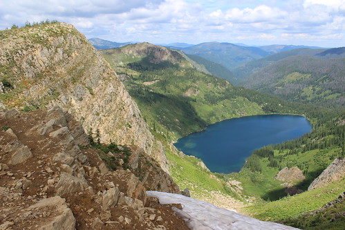
At the junction, we continued west on switchbacks above Heart Lake into a high meadow that held the bare stalks of what must have been a beautiful beargrass bloom a month earlier. The trail then switchbacked up to the ridge that forms the border with Idaho and the junction with the Stateline Trail - Trail 738 - at about 4 1/3 miles. Here, we stopped to eat and saw the first of a handful of mountain goats in the distance along the rocky ridge.
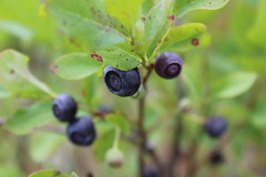
The Stateline followed the ridge southeast, passing a rocky point at 4 3/4 miles and a chute still holding snow at 5 3/4, both providing views of the lakes below. Along the way, we found plenty of huckleberry bushes filled with juicy, tart fruit.
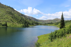
At about 6 miles, we left the Stateline at a junction with Trail 620 and dropped northeast to a saddle between Pearl and Dalton lakes. From there, we continued down Trail 175 and back west around Pearl Lake to its outlet at about 7 1/2 miles, then down again and north to the first junction below Heart Lake at 8 2/3 miles, letting the dogs swim multiple times along the way.
After that, we retraced Trail 171 back east and north 2 3/4 miles to our vehicle.
See more photos from Heart and Pearl lakes.
Distance: 11 1/2 mile loop.
Trailhead: From Superior, follow Diamond Match Road southeast and Trout Creek Road southwest - one turns into the other - for 19 miles.