July 20, 2014

A smoky run up Stuart Peak

My feet atop Stuart Peak

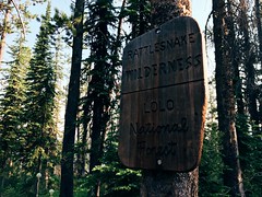
Wildfire smoke filling the valley last week didn't deter a friend and I from getting out on a long run Saturday morning - in fact, an early start provided a short, clear window on our way up 7,971-foot Stuart Peak in the Rattlesnake Wilderness.

Looking up from the main Rattlesnake National Recreation Area trailhead we could see blue sky, but on the way down summer's heat and smoke from out-of-state fires set in.

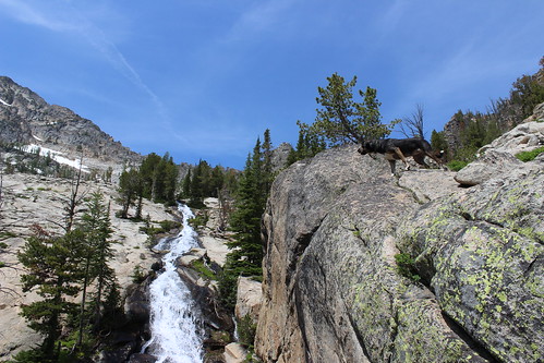
We started out somewhat early following the main trail, Trail 515, north for 2/3 of a mile. From there, we followed the shadier Trail 517.1 up the east side of Spring Creek for about 1 2/3 miles, then crossed over to Trail 517 on the west side and continued. After the Wallman Trail veered off at about 3 miles, the trail began a steep section, reaching at junction with Trail 24.1 from the west at about 4 1/4 miles.

Rattlesnake Wilderness sign on the Stuart Peak trail

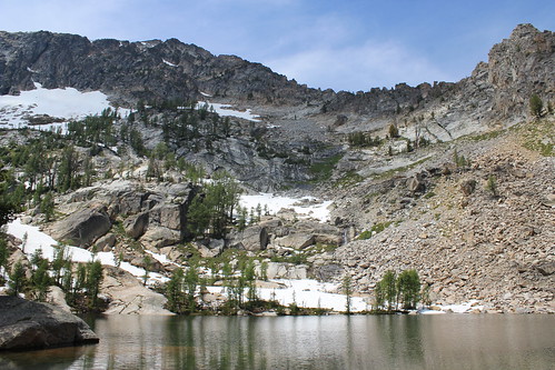
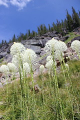
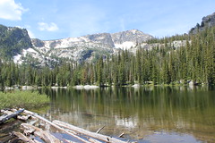
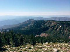
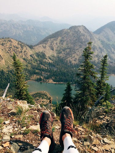
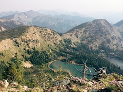
From the junction, we continued northeast on 517 up a couple of long stretches and a couple of series of switchbacks, the forest thinning and beargrass increasingly blooming as we rose. At 7 3/4 miles we reached the top of the switchbacks and the Rattlesnake Wilderness boundary. From there, we continued 1 1/4 miles on a flat to slightly uphill stretch to an overlook of Twin Lakes.

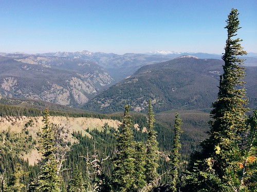
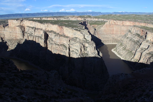
The final stretch followed a steep, rough trail along the ridgline to the southeast from Trail 517 about 1/2 mile to Stuart Peak, bringing our elevation gain to more than 4,200 feet. Most days, you can see south to Missoula and the Bitterroot Mountains or north across the wilderness to the Mission and Swan ranges. With the smoke however, we could see only the lakes below and other mountains in the immediate area.

Smoke and sun on my run up Stuart Peak

After stopping at the top for some photos and to eat, we backtracked to the trailhead, finding it hotter and smokier than when we left about 4 hours and 15 minutes earlier.


Beating the heat at 3 Bitterroot lakes

baker_lake_2014-07-13_100

To beat the heat last Sunday, we took the dogs on a hike to to a trio of lakes that lie just below 10,157-foot Trapper Peak, the highest in the Bitterroot Mountains. The trail to Baker, Middle and Gem lakes is short and steep, but worth the view.

baker_lake_2014-07-13_017

The trail begins uphill to the south of the parking area, then switchbacks steeply west to Boulder Point at a little less than half a mile. After a short section through the forest, the trail crosses a south-facing slope, descending slightly and passing through several open stretches filled with beargrass. The trail then climbs into the forest to Baker Creek, where fallen trees block the way. From here, it's easiest to walk uphill over the flat rock along the creek to the shore of Baker Lake at about 1 1/2 miles. Several campsites are available here, and Trapper Peak stands above the drainage to the west.

baker_lake_2014-07-13_034

Rounding the lake on either side - we went north, through a small boulder field - the trail continues along a marshy stretch of creek though the forest about another mile to Middle Lake, entering the Selway-Bitterroot Wilderness along the way.

baker_lake_2014-07-13_063

From Middle Lake, the trail stays north of the creek and rises steeply out of the forest onto more flat rock and along a cascade about 1/3 of a mile to Gem Lake. The clear pool of water sits with snow at its edge even in July, with the false summit of Trapper Peak directly above it to the west. The water was so cold, in fact, that the dogs opted not to swim at Gem.

After a short break - mostly spent swatting at mosquitoes - we made our way back downhill to the trailhead.

Here are more photos from Baker, Middle and Gem lakes.

Distance: 5 1/2 miles round trip.

Trailhead: From Darby, drive about 4 1/3 miles south on U.S. Highway 93 and turn onto West Fork Road. Follow West Fork Road south for 7 miles, then turn northwest onto Pierce Creek Road. (While this turn is listed as being signed in guidebooks and on websites, we found none; the road is adjacent to mile marker 7 and has fenced pastures on each side.) Drive uphill northwest through an intersection; at a second intersection about one mile up, continue northwest as directed by a sign 9 miles to the Baker Lake trailhead.

July 17, 2014

Sheep Mountain marathon before the marathon

My Missoula trail marathon today: Out Rattlesnake Creek, back over Sheep Mountain

Last Saturday - the day before the Missoula Marathon - a friend and I decided to run a marathon of our own up Rattlesnake Creek and back over Sheep Mountain and Blue Point.

The day was hot, so we started early, and after a few short side trips ended at 26 1/2 miles and nearly 5,100 feet of elevation gain.

My Missoula trail marathon today: Out Rattlesnake Creek, back over Sheep Mountain

From the main Rattlesnake National Recreation Area trailhead, we followed the wide Trail 515 for eight rolling miles to Franklin Bridge, stopping there to filter some water. A short distance up the hill from the bridge, we turned east on Trail 514 and climbed about 1 1/2 miles through the forest above the East Fork of the creek. When the trail reached another junction, we continued southeast downhill, still on 514, and crossed the creek, then climbed again through the forest thick with beargrass. At the next junction, a little more than 1 3/4 miles later, we continued southeast again a short distance until reaching Trail 513 between Sheep Mountain and Mineral Peak.

My Missoula trail marathon today: Out Rattlesnake Creek, back over Sheep Mountain

Turning west on 513, we followed the wide ridge southwest then switchbacked steeply up to the top of 7,646-foot Sheep Mountain at about 15 1/2 miles, where we took another break at a small stone-walled shelter. After eating and taking in the view, we continued about 3 3/4 miles along the open ridge over another small point, down below treeline and back up to the Blue Point junction. After a 1/2-mile out-and-back detour to the overlook, we returned to Trail 513 and followed the ridge down about 4 miles into Woods Gulch. After another brief stop to refill our packs with water, we continued west down to the trailhead and followed roads about a mile back to the main Rattlesnake trailhead.

After about six hot hours out we had our mountain marathon.

(Note: My GPS malfunctioned, resulting in all laps being recorded, but only half a map, so it isn't posted here.)

July 4, 2014

The road home through Yellowstone

midway_geyser_basin_2014-06-22_083

After the Bighorn Mountain Wild and Scenic Run near Sheridan, Wyoming, we turned back toward home - but as with the drive down, we took the slower road and came through Yellowstone National Park.

On the first of day of our two-day drive, we came west through Cody and the east entrance, over Sylvan Pass, past Yellowstone Lake, north to the geyser basins along the Firehole River and down the Madison River to West Yellowstone. The second day, we drove back up the Madison, then the Gibbon River to the Norris Geyser Basin, departing the park on the north at Gardiner. Along the way, we saw full rivers and waterfalls, colorful thermophiles, bubbling mud and steaming pools - and got stuck in summer wildlife jams, first for bison and then for a bear.

Since it was a tour of roadside attractions, I decided to put my photos together in a slideshow.

July 3, 2014

Big canyon, bighorns, wild horses on the state border

devil_canyon_2014-06-18_002

On our trip to Wyoming recently, we took the longer, more scenic route south and camped for a night at Bighorn Canyon National Recreation Area, which straddles the border with Montana north of Lovell.

While it's perhaps better known as a boating destination, we found a couple of short trails with spectacular views of the canyon's colorful cliffs, as well as wildflowers and wildlife. (I was taking it easy before the Bighorn Mountain Wild and Scenic Trail Run, anyway.)

The day we arrived, we drove the main road north from our campsite at Horseshoe Bend along the west rim of the canyon to its end, stopping at a few spots along the way.

Devil Canyon Overlook

devil_canyon_2014-06-18_148

The first was Devil Canyon Overlook, where you can look down 1,000 feet to Bighorn Lake from a fenced-off parking lot. Below, Porcupine Creek enters the lake from the east.

That evening, we returned to the overlook and found ourselves amid a herd of grazing bighorn ewes and lambs. We also caught the last daylight rising up the canyon walls and lighting the rocks at the top.

devil_canyon_2014-06-18_032

Location: From Lovell, drive about 2 1/2 miles east on U.S. Highway 14A, 15 1/2 miles north on Wyoming Highway 37 and 1/2 mile east on the overlook road.

Sullivan's Knob Trail

sullivans_knob_2014-06-18_007

A short distance north on the road, we pulled over and hiked the Sullivan's Knob Trail, rounding a rocky outcrop and dropping slightly to the edge of the canyon.

Along the way, we found an abundance of prickly pear cactus in bloom, as well as birds.

Distance: 1 mile round trip.

Trailhead: From Lovell, drive about 2 1/2 miles east on U.S. Highway 14A and 16 miles north on Wyoming Highway 37.

Ranger Delight Trail

ranger_delight_2014-06-18_057

After driving to the Barry's Landing boat ramp at the end of the paved road, we turned back and stopped south of the overlook at the Ranger Delight Trail.

Here, the trail climbed to the canyon edge above a large bend in the lake and provided a view back to the red rocks near our campsite.

Distance: 1/2 mile round trip.

Trailhead: From Lovell, drive about 2 1/2 miles east on U.S. Highway 14A and 14 miles north on Wyoming Highway 37.

crooked_creek_2014-06-19_133

Before we departed for Sheridan the next morning, we made another quick drive up to the overlook. On the way, we found a few wild horses just inside the Pryor Mountain Wild Horse Range near Crooked Creek.

More photos of Bighorn Canyon are here.