May 14, 2012

Flowers, falls and a first hike

bear_creek_20120513_084

We took advantage of a beautiful spring day to drive up the Bitterroot Valley and take our new dog on her first real hike, to Bear Creek.

After a month of walking on leash and getting familiar with her new family, Josey got to run under voice control for the first time last week. After an initial burst of excitement, she did well, sticking close to our other dog Belle.

bear_creek_20120513_111

On Sunday, we went into the woods near Victor, following the trail along Bear Creek an easy 1 1/2 miles up. The creek was full, with two channels spilling over the falls, and along the way we found plenty of wildflowers - fairy bells, fairy slipper orchids and some fading trilliums and glacier lilies.

We also found out a couple of things about Josey: She's a water dog, always looking for a way down to the creek or into a mud puddle. And she's a roller; we'll have to be on the lookout for horse droppings.

Here are more photos from Bear Creek.

Distance: 3 miles round trip.

Trailhead: From Victor, drive 3.3 miles south on U.S. Highway 93, 2.3 miles west on Bear Creek Road, 0.8 miles north on Red Crow Road and 3.2 miles west on Red Crow and Bear Creek roads. 

April 22, 2012

Josey says hello!

north_hills_20120408

Meet our new dog, Josey!

Josey was a stray found in the Bitterroot Valley that we adopted from the Humane Society of Western Montana recently. She's a 2-year-old rottweiler/hound cross, and large - she was listed at 94 pounds at the Humane Society, but weighed in at 88 at our vet.

After a few weeks, she's settled in quite well at the house and with our 8-year-old Lab/hound Belle. The two are enjoying playing and going on walks together, and sharing the couch when we're out, apparently.

We're looking forward to getting out into the mountains with Josey after a bit more training!

March 27, 2012

Foggy at Freezout Lake

freezout_20120325_247

We took a long weekend and spent part of it across the Continental Divide, checking out the spring waterfowl migration at Freezout Lake Wildlife Management Area between Fairfield and Choteau.

While halfway decent weather and more than 50,000 snow geese were in the forecast before we left, we found a lot of fog and fewer birds. Still, the trip was worth it for the ease of viewing and the species present.

freezout_20120326_029

Freezout offers several roads and trails among the main lake and a series of ponds on the plains just east of the Rocky Mountain Front. Every year in mid- to late March thousands of snow geese stop in the area on the migration north. Several other species can be seen, as well, including Canada geese, tundra swans, American white pelicans, northern pintails, great blue herons and more.

freezout_20120326_105

The last time we visited Freezout, more snow geese were passing through and the lake and ponds were still partially frozen, concentrating the birds on open water. This time, a Montana Fish, Wildlife and Parks representative told us, the fog kept what geese there were in nearby fields. We saw a number of species, but overall numbers were low.

freezout_20120325_147

If you're thinking of visiting Freezout, check the spring waterfowl hot line at (406) 467-2646.

See pictures from Freezout Lake here.

Distance: Several roads run through the wildlife management area, from which you can walk among the lake and ponds.

Trailhead: From Fairfield, drive 4 miles north on U.S. Highway 89 to the main entrance and information kiosk.

February 26, 2012

Back on the racecourse

After 13 months of healing an injured Achilles tendon, I ran the Snow Joke Half Marathon in Seeley Lake yesterday, and it went well.

At 1 hour, 44 minutes and 47 seconds, the finish was exactly 3 minutes off my half marathon PR - not bad considering all of the time off and the heavy snowfall and snowpacked road around the back of the lake.

Having passed this test of sorts, I plan to enter a couple of my favorite local half marathons this year - the Pengelly Double Dip and the Mountain to Meadow - as well as some other unique races in the area - the Riverbank Run Trifecta, 11 Miles to Paradise and, possibly, the Blue Mountain 30K. Unfortunately, I'll be out of town for the Missoula Marathon.

January 23, 2012

Winter in the Sonoran Desert

labarge_boulder_20120112_052

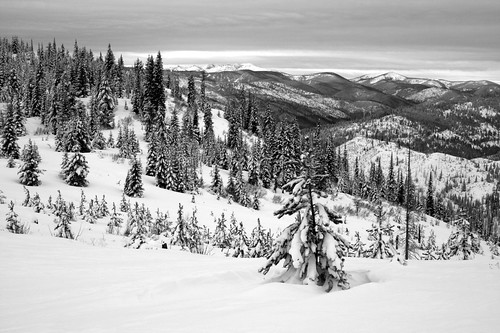
Shortly before Christmas, we noticed an airfare sale between Missoula and the Phoenix area, and knowing family would be there in January we bought some tickets. At that point, western Montana's winter had been fairly mild and offered little opportunity for any real recreation in the snow, so we were glad to go south to the Sonoran Desert.

While Phoenix is a sprawling city, there are plenty of opportunities to get out. And while based west of the urban area, we also took short trips to Tucson and into the Superstition Wilderness.

Saguaro National Park: Wasson Peak

wasson_peak_20120108_051

There are several trailheads in 
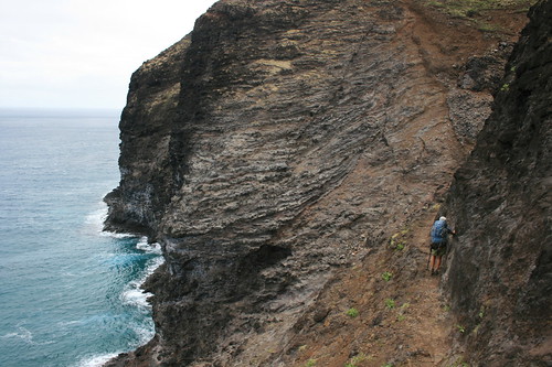
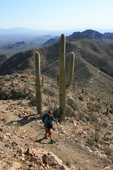
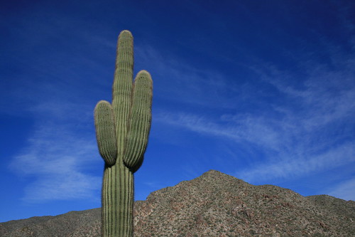
Saguaro National Park's western unit that provide access to Wasson Peak, the highest in the Tucson Mountains at 4,687 feet. Several years ago - on our first visit - we hiked up via the Sendero Esperanza Trail, which begins along an unpaved road. This time, we used the King Canyon Trail just off a paved road east of the park's Red Hills Visitor Center.

For the first mile, follow the official trail along an old Civilian Conservation Corps road or walk up the King Canyon Wash northeast to a junction near the Mam-A-Gah picnic area.

From the junction, the trail climbs northeast up a saguaro cactus-covered slope for nearly a mile and a half to another intersection that overlooks the city. Turn northwest here and hike for nearly a mile up and across a steep mountainside to a junction with the Hugh Norris Trail at a saddle below Amole Peak. From here, it's a quick third of a mile out a ridge and up the final steps to Wasson Peak.

wasson_peak_20120108_070

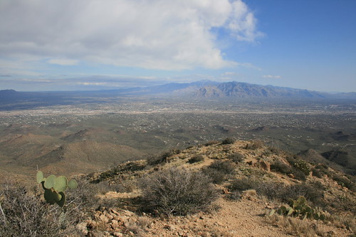
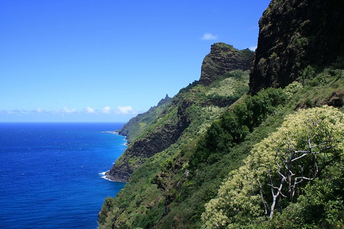
Wasson provides views across Tucson to the Tortolita and Santa Catalina mountains to the northwest, the Rincon Mountains to the east and the Santa Ritas to the south.

wasson_peak_20120108_090

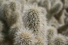
To return to the King Canyon trailhead, we made a loop via the Hugh Norris and Sendero Esperanza trails. From the junction at the saddle, follow the Hugh Norris west past Amole Peak and down the ridge nearly 2 miles. At the Sendero Esperanza junction, turn southeast and continue about a mile and a half past cholla cactuses and an old mine back to the Mam-A-Gah picnic area.

From here, it's about a mile back down the trail or wash to the parking area.

See more photos from our Wasson Peak hike here.

Distance: 8 miles.

Trailhead: The King Canyon trailhead is 2 miles east of Red Hills Visitor Center on Kinney Road in the western unite of Saguaro National Park. (The park entrance fee is $10 per vehicle, payable at the visitor center.)

White Tank Mountains: Ford Canyon to Mesquite Canyon

ford_mesquite_20120110_013

Located on the western edge of Phoenix's suburbs, White Tank Mountain Regional Park was closest to where we stayed for the majority of our visit.

From the parking lot at picnic area 9, walk northeast from the trailhead sign down through a wash then up to the Ford Canyon Trail. Turn northwest and follow the trail to the canyon through a saguaro- and cholla-covered flat past junctions with the Ironwood and Waddell trails.

ford_mesquite_20120110_037

After about 1.75 miles, the trail begins to ascend Ford Canyon through white granite boulders and a wash, and leaving views of the urban area behind. The path climbs up a couple of granite walls and a dam, then leaves the wash at about 4 miles.

The trail continues south up grassy slopes, over a ridge and down into Willow Canyon, where ocotillo are more abundant, to a junction at 5.5 miles. Switchback uphill to a junction at nearly 6.5 miles and turn northeast onto the Mesquite Canyon Trail.

ford_mesquite_20120110_119

The Mesquite Canyon trail continues around a ridge then downhill to the Willow Canyon junction at nearly 8 miles. Here, the trail drops back through a white granite canyon about 1.7 miles to the valley floor near picnic area 7.

Follow the Waddell Trail north about a mile to Ford Canyon, then southeast nearly two-thirds of a mile back to the parking area.

More pictures from the White Tank Mountains are here.

Distance: 11.2 miles.

Trailhead: From Interstate 10 in Goodyear, Ariz., west of Phoenix, take Arizona Highway 303 about 7.2 miles north to Olive Avenue. Follow Olive 4.5 miles west to the entrance of White Tank Mountain Regional Park ($6 per car). The trail begins across from the parking lot at picnic area 9.

Superstition Wilderness: Boulder Canyon and LaBarge Canyon

labarge_boulder_20120112_125

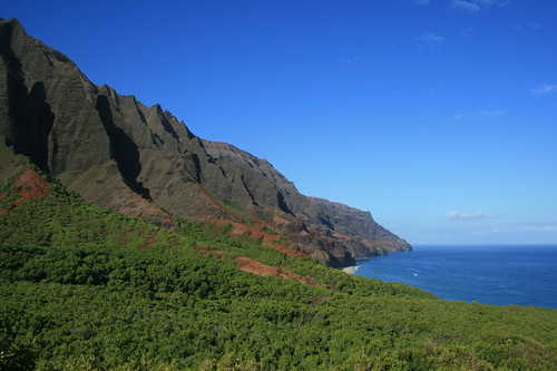
The final hike of our trip was probably our favorite. The route up Boulder and LaBarge canyons in the Tonto National Forest's Superstition Wilderness provides scenic views of cliffs and cactuses, as well as an off-trail segment.

The hike begins on the south side of Arizona Highway 88, across from Canyon Lake Marina. The Boulder Canyon Trail steadily climbing a hill southeast to the wilderness boundary marker at about half a mile.

labarge_boulder_20120112_169

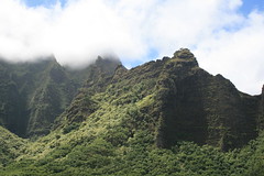
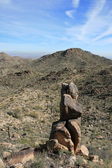
At about 1.25 miles, the trail reaches its high point and offers views up Boulder and LaBarge canyons to the squared-off Battleship Mountain and Weaver's Needle in the distance. The trail drops slightly, then rounds a hill and passes an orange, rocky outcrop. Up a hill to about 2.2 miles, the route reaches another viewpoint into the canyons ahead.

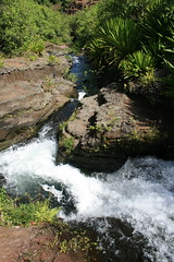
From here, the trail descends switchbacks past saguaros and barrel cactuses to the canyon floor, crossing LaBarge Creek at about 3.3 miles. Begin walking up the creek bed - it was mostly dry when we were there but likely flows at other times of the year - here or cross and join it by leaving the trail after a small rise near a campsite.

labarge_boulder_20120112_103

Once in the creek bed, follow cairns upstream to the south between Battleship Mountain on the west and Geronimo Head to the west, aiming for the triangular summit ahead. 
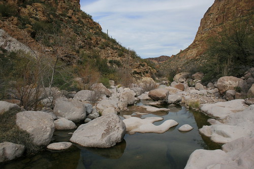
Boulder hopping up the creek bed was the most strenuous part of this hike, and we eventually reached a few sections of slowly flowing water that we had to cross.

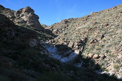
About 1.2 miles upstream, a box canyon begins with high walls and a spire and pool at its mouth. Stop here to rest and explore the start of the slickrock canyon.

To continue, look for cairns starting under the trees at a campsite on the western edge of the pool that mark a route up to the saddle between the canyon and Battleship Mountain. The climb is not too steep and the cairns are easy to follow, and the saddle provides another view of Weaver's Needle.

Once over the saddle, continue following the cairns downhill to Boulder Creek, crossing it - again, dry when we were there - and reconnecting with the trail on the other side.

labarge_boulder_20120112_153

The Boulder Canyon Trail travels north, crossing the creek back and forth past a large pool and Battleship Mountain on the east, then the Second Water Trail on the west.

After crossing the creek bed a final time, the trail climbs a saddle past an old mine and drops to the campsite and LaBarge Creek at 3.3 miles from the start. Follow the route back up to its high point, then down to the trailhead near the marina.

Boulder and LaBarge canyon photos are here.

Distance: 10.5 miles.

Trailhead: From U.S. Highway 60 in Apache Junction, east of Phoenix, drive 2.25 miles north on Idaho Road to Arizona Highway 88. Follow Highway 88 northeast 14 miles to the Canyon Lake Marina. (Park in the trailhead parking facing the fence that parallels the highway.)

January 14, 2012

New Year's snowshoe at Lolo Pass

lolo_pass_20120101_025

After a busy - and somewhat sad - holiday season, we sought to start off the new year right on a short snowshoe adventure with friends at Lolo Pass on the Montana-Idaho border.

Despite cloudy skies, we had a good day making first tracks in a small amount of powder and going sledding back at the Lolo Pass Visitor Center.

Follow the snowshoe trail up the hill to the south of the visitor center and past a junction. At the top, the trail continues out a ridge that offers good views into Idaho then down a powder-filled slope, crossing a groomed road before reaching Pack Creek. The trail follows along the creek then a cross-country ski trail, and loops back to the junction near the start.

lolo_pass_20120101_048

See more photos from Lolo Pass here.

Distance: About 3 miles.

Trailhead: From Missoula, drive 9 miles south on U.S. Highway 93 to Lolo, then 32 miles west on U.S. Highway 12 to the Lolo Pass Visitor Center, just over the border in Idaho. (Parking costs $5.)

Farewell to our faithful friend Gigi

gigi_20120114_003

Shortly before Christmas, we lost our most faithful hiking companion, Gigi. Our hound-Lab-shepherd was believed to be 16 to 17 years old.

She was a traveler. From the Pacific Coast to the North Shore of Lake Superior and Montana's mountains to the desert Southwest, she would follow wherever we went.

She was a survivor. From the streets of Philipsburg to a run-in with a minivan to tumors that forced the amputation of a toe to the removal of a section of intestine after she ate a bandage, she always forged ahead.

And she was one of a kind. From her smile to her orange coat and white feet to the howl that let you know it was time to go, there will never be another like her.

We love her and miss her, and know that she will always be just past that last hill in the distance.

Farewell, Garbage Guts, Good Girl, G.G., Gigi!

October 5, 2011

Miles in Montana, beyond

Looking at the blog lately, it would appear we've been hiking more outside of Montana than in. The numbers bear that out as a whole, although Montana is the state with the most miles.

Here's our mileage and days on the trail by state since the start of May:
  • Montana: 37.3 miles over six days
  • Hawaii: 26 miles, three days
  • Oregon: 22.4 miles, three days
  • Utah: 15.8 miles, three days

Note that this also doesn't include dog walks and runs on trails near town.

Oregon's Cascades and coast

paradise_park_20110929_042

Last week, we returned to my home state of Oregon for a follow-up gathering to August's wedding and to visit friends who recently moved there. As usual, we took the opportunity to get out, hiking on the Oregon Coast and in the Cascade Mountains.

First up was a short trip to Hart's Cove at the Siuslaw National Forest's Cascade Head Scenic Research Area near Lincoln City, an easy drive west from our friends' house in Monmouth. We got a glimpse of the sun through the fog and took in crashing waves and a small waterfall that spills into the sea.

On the way back to Portland from Monmouth, we stopped by Silver Falls State Park in the low Cascades to walk the Trail of Ten Falls. It's similar to the Columbia River Gorge, with water flowing over basalt cliffs.

Finally, we took a day to drive up to Timberline Lodge on Mount Hood and hiked a section of the Timberline Trail/Pacific Crest Trail to Paradise Park. The path crosses the Zigzag Canyon to a wildflower-filled meadow that was still in bloom at the end of September.

Thanks go to PortlandHikers.org, which has helped us discover a couple of these and several other adventures in the area.

Oregon Coast: Hart's Cove

harts_cove_20110927_228

While visiting Monmouth, friends suggested going for a hike to Hart's Cove in the Coast Range near Lincoln City, which they had heard about. The next morning, three of us made the drive to the trailhead.

harts_cove_20110927_031

The trail begins by switchbacking down nearly 1,000 feet through a lush Sitka spruce and Western hemlock rainforest. At half a mile, it crosses Cliff Creek and continues generally north.

After crossing Chitwood Creek, the trail leaves the forest at an open headland at 2.7 miles, the destination. From the south side of the headland, the small Chitwood Falls can be seen dropping into Hart's Cove. A trail also leads closer to the water on the west side. All around, waves crash onto the steep, rocky coastline.

We had a bite to eat and played a game of cribbage while the morning fog cleared, then heard and saw sea lions offshore as we started the climb back to the trailhead.

harts_cove_20110927_137

See Hart's Cove photos here.

Distance: 5.4 miles round trip.

Trailhead: Turn west on the unsigned Forest Road 1861, about 8.75 miles north of Lincoln City on U.S. Highway 101, and follow it about four miles to the end.

Silver Falls State Park: Trail of Ten Falls

The Trail of Ten Falls at Silver Falls State Park, near Salem and Silverton, has a wonderful 8.7-mile trail through lush forest and along creeks that passes nine, 10 or 11 waterfalls along the way - depending on your definition of a waterfall. We broke up our drive back to Portland with a stop to hike. With photos of so many waterfalls, this trip seemed like a good candidate to try Storify's new slideshow feature. Follow along below.


More Silver Falls photos are here.

Mount Hood: Paradise Park

paradise_park_20110929_083

Jen had hiked on Mount Hood on a previous trip but had never been up to the historic Timberline Lodge, so we made a day trip of it from Portland. After a quick look in the hotel, we set out northwest on the Timberline Trail/Pacific Crest Trail.

paradise_park_20110929_129

The path passes behind the lodge and sets out under lifts on ski runs where I learned to downhill as a child. It crosses into the Mount Hood Wilderness and continues gently down through the forest and Little Zigzag Canyon, then past a trail junction. Along the way, the summit of Hood can be seen to the north, and Mount Jefferson and the Three Sisters to the south on clear days.

An overlook of the gaping Zigzag Canyon is reached at about 2.2 miles. Here, the view includes the rushing Zigzag River, the rocky Mississippi Head and above it Zigzag Glacier.

paradise_park_20110929_050

The trail then switchbacks steeply down through the trees for a mile to the river. Depending on the water level, the stream can be forded, or scramble across on rocks. Zigzag Falls can be seen a short distance upstream.

Not quite half a mile up out of the canyon, the trail reaches a junction with the 2.6-mile Paradise Park Loop. Here, we turned northeast and continued climbing out of the forest to the junction with the Paradise Park Trail at nearly 4.6 miles, where we found fields filled with blue lupine, purple asters, red paintbrushes and more.

paradise_park_20110929_065

A short distance above the junction, we stopped at a grassy overlook to take in the view, eat and fly a kite before backtracking to Timberline.

See pictures from Paradise Park here.

Distance: About 9.5 miles round trip. Paradise Park begins about 4.6 miles northwest of Timberline Lodge on Mount Hood, at the junction of the Paradise Park and Paradise Park Loop trails.

Trailhead: Behind Timberline Lodge, three-quarters of a mile east of Government Camp on U.S. Highway 26 and 5.3 miles northeast on Timberline Highway.

September 14, 2011

Island tri: Snorkeling, hiking, paddling Kauai

kalalau_20110901_221

After a busy August of work and hosting family and friends, we jetted to Hawaii for my brother's wedding on Kauai. We packed our backpacks and took the opportunity to explore some classic outdoors spots.

Before the wedding at Anini Beach, we checked out some colorful fish on a snorkeling outing. With equipment rented from a shop in Hanalei, seeing the sea life at Tunnels Beach was as easy as swimming into the mild surf from shore. The activity also allowed us to finally put Jen's underwater point-and-shoot camera to the test - we bought it a couple of years ago for a trip to Australia but never really dunked it. We spent a few hours with it in the saltwater, and it did a fine job on both photos and videos.

tunnels_20110828_029

After the wedding, we stayed around Hanalei for a handful of days for some post-family fun.

First was a three-day, two-night backpacking trip out the 11-mile Kalalau Trail on Kauai's famed Na Pali Coast. The trail was long, hot, humid and at times crowded, but the views - of the cliffs during the day and the sunsets and stars at night - were well worth it. On the middle day, we hiked upstream through the Kalalau Valley to a deep pool perfect for a swim then strolled out the beach. Read more about the trails below.

Back in Hanalei for our last full day on the island, we rented stand-up paddleboards and made our way up the calm river to the taro fields and down to the bay, where the surf picked up a bit.

From the wedding to the walking, it was a great vacation. Congratulations to the newlyweds, and thanks for the wonderful break!

Days 1 and 3: Kalalau Trail

kalalau_20110831_069

The Kalalau Trail is an 11-mile route along the dramatic fluted cliffs of Kauai's northern coast, beginning at Haena State Park and crossing into Na Pali Coast State Wilderness Park. Due to packing our bags at the wedding accommodations, last-minute shopping and taking a shuttle to the trailhead, we got a late-morning start on the trail.

The first couple of miles are on a wide, rocky path that climbs westward through shady vegetation then descends to a creek crossing and Hanakapi'ai Beach. It provides good views west along the Na Pali Coast, but is crowded.

kalalau_20110831_019

After crossing the first stream, the route switchbacks up out of the Hanakapi'ai Valley and leaves behind the crowd - except for the near constant buzz of helicopters in the sky above and procession of boats in the ocean below.

High above the water, the trail continues its westward traverse through thick vegetation, back into hanging valleys then out and around ridgelines that plunge to the water. Many of the ridges are accompanied by sets of switchbacks up and then down, adding elevation gain.

At six miles, the Hanakoa Valley and stream are reached. Here, there's a camp for backpackers not hiking the full 11 miles and a short trail - which we didn't take - that provides views of Hanakoa Falls, spilling from the mountains above. Running short on water, we filtered at a nearby creek then moved on.

kalalau_20110902_093

From Hanakoa, the trail continues into valleys and around ridges, but the land becomes drier and the vegetation more open. Soon, the trail reaches a rocky ravine that spills to the sea. After a short descent, to about 300 feet above the ocean, it rounds a narrow cliff called Crawler's Ledge - definitely not a place for a misstep.

kalalau_20110902_075

Beyond Crawler's Ledge, the traverse continues, with Kalalau Beach and the fluted cliffs above and beyond it coming into view. We reached this area in the late-afternoon heat and found our water running short, but pressed ahead.

After passing what appears to be a defunct camp, the trail makes a final climb around a ridge to the top of Red Hill, where the ground is rust colored and the view over the Kalalau Valley and beach is wide open.

Once down, the route crosses Kalalau Stream at 10.5 miles then a final hill before a straightaway to the camp and beach. As Jen filtered water again at the stream, I caught the sun setting before finding a suitable site for our tent under the trees just off a rocky part of the beach.

kalalau_20110902_011

Two days later, we had a much easier time on the way out due to a couple of changes. First, we started before 8 a.m., allowing us to get through the drier terrain in the morning hours. Second, we made a few more regular stops to filter water, no matter how much we had left, to ensure we had plenty to drink.

A few words about camping at Kalalau: Hawaii State Parks requires permits, which you can buy online and print at home. We met people who didn't have them and ours were never checked; nonetheless, we don't mind paying for management and preservation of special places. Unfortunately, while the trail is one of the most scenic we have hiked, the camps were some of the dirtiest we have seen and obviously the victims of years of abuse and/or neglect. Pack it in, pack it out, people. And don't get me started on the composting toilets.

More pictures from Kalalau Trail and beach are here and here.

Distance: 11 miles one way.

Trailhead: The Kalalau Trail begins at Haena State Park, about 7.25 miles west of Hanalei on Hawaii Highway 560, the Kuhio Highway.

Day 2: Kalalau Valley and beach

kalalau_20110901_079

The middle day of our backpacking trip was spent wandering around Kalalau.

That morning, we followed the end-of-valley trail upstream through the forest. Along the way we passed several cascades, stands of bamboo and old terraces where taro was once grown. The trail ends at a deep, cool pool, where we took a swim and ate a snack before returning to camp.

kalalau_20110901_115

Later in the day, we wandered a short distance up the beach past several sea caves - some of which people had set up camp in - at the base of the cliffs.

Distance: The end-of-valley trail is four miles round trip.

Trailhead: The end-of-the-valley trail begins just west of the Kalalau stream crossing, near Kalalau Beach.