Showing posts with label Bitterroot National Forest. Show all posts

July 20, 2014

Beating the heat at 3 Bitterroot lakes

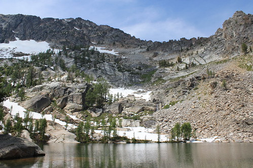
baker_lake_2014-07-13_100

To beat the heat last Sunday, we took the dogs on a hike to to a trio of lakes that lie just below 10,157-foot Trapper Peak, the highest in the Bitterroot Mountains. The trail to Baker, Middle and Gem lakes is short and steep, but worth the view.
baker_lake_2014-07-13_017

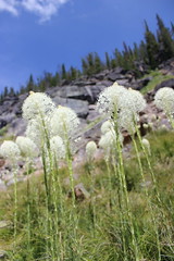
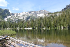
The trail begins uphill to the south of the parking area, then switchbacks steeply west to Boulder Point at a little less than half a mile. After a short section through the forest, the trail crosses a south-facing slope, descending slightly and passing through several open stretches filled with beargrass. The trail then climbs into the forest to Baker Creek, where fallen trees block the way. From here, it's easiest to walk uphill over the flat rock along the creek to the shore of Baker Lake at about 1 1/2 miles. Several campsites are available here, and Trapper Peak stands above the drainage to the west.
baker_lake_2014-07-13_034

Rounding the lake on either side - we went north, through a small boulder field - the trail continues along a marshy stretch of creek though the forest about another mile to Middle Lake, entering the Selway-Bitterroot Wilderness along the way.
baker_lake_2014-07-13_063

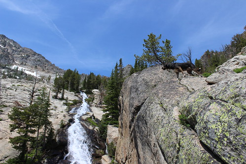
From Middle Lake, the trail stays north of the creek and rises steeply out of the forest onto more flat rock and along a cascade about 1/3 of a mile to Gem Lake. The clear pool of water sits with snow at its edge even in July, with the false summit of Trapper Peak directly above it to the west. The water was so cold, in fact, that the dogs opted not to swim at Gem.

After a short break - mostly spent swatting at mosquitoes - we made our way back downhill to the trailhead.

Here are more photos from Baker, Middle and Gem lakes.

Distance: 5 1/2 miles round trip.

Trailhead: From Darby, drive about 4 1/3 miles south on U.S. Highway 93 and turn onto West Fork Road. Follow West Fork Road south for 7 miles, then turn northwest onto Pierce Creek Road. (While this turn is listed as being signed in guidebooks and on websites, we found none; the road is adjacent to mile marker 7 and has fenced pastures on each side.) Drive uphill northwest through an intersection; at a second intersection about one mile up, continue northwest as directed by a sign 9 miles to the Baker Lake trailhead.

February 4, 2014

Canine-friendly cross-country skiing at Como Trails

como_trails_20140202_066

On Sunday, we traveled south of Hamilton to give the dog-friendly Como Trails cross-country ski area a try and found near solitude, encountering only a handful of people in the first and last mile.

There are plenty of places around Missoula to ski with dogs, but Como is one of only two that allows them on groomed trails. (The other is at Lubrecht Experimental Forest.) It's also the newest cross-country ski area in the region, opening in the winter of 2009-10, and this was our first trip there.

The trails begin above the shores of Lake Como, weaving over and among the ridges to the south. Not being familiar with them, we chose a loop that included Panorama Point, hoping for a good view.

como_trails_20140202_024

Our route began on a groomed road, then turned onto a narrower trail through the trees. After about 1 1/2 miles, we ascended a steep, untracked section of powder called Uff-Da to Panorama Point. Atop the ridge, we could see the surrounding mountains - the Bitterroots continuing to the west and the Sapphires across the valley to the east - but Lake Como was out of sight, beyond a ridge to the north.

After stopping briefly at the point, we followed a flat trail along the ridge to the next junction, then turned south and skied down to the Chute, which drops steeply to a lower trail at about three miles.

From the bottom of the Chute, it's five miles back to the parking lot on a wide, groomed trail that rolls through a relatively open forest of tall pine trees. Along the way, we passed a couple of parcels of fenced-off property that required a little dog calling - there were horses in one area - but otherwise were no trouble.

como_trails_20140202_070

We never did get a view of the lake, but there are more trails to explore in the future.

Here are more photos from skiing at Como Trails.

Distance: 8-mile loop. The area has a total of more than 30 miles of groomed trail.

Trailhead: Parking for Como Trails is 12 1/2 miles south of Hamilton on U.S. Highway 93, then 4 miles west on Lake Como Road, above the boat ramp.

July 5, 2013

Hiking up, up, up to Canyon Lake

canyon_lake_20130630_203

Last weekend, with temperatures rising into the 90s around western Montana, we decided to hike up to a lake in the Bitterroot Mountains.

We've hiked the Canyon Lake trail a few times before, but for various reasons never gone all the way to the lake, instead turning back about halfway up the steepest section at an overlook of Canyon Falls. This time, we continued the rest of the way up and found the lake a refreshing spot to stop for lunch.

canyon_lake_20130630_015

From the trailhead, the route quickly enters dense forest, roughly paralleling the Canyon Creek to the north. Here, we found an abundance of hairy cat's ear and queen's cup wildflowers.

The trail continues through the forest, occasionally meeting the creek or an opening in the trees revealing the rocky cliffs on the north side of the canyon, for about four miles. Along the way, we began to see beargrass, which is in profusion around western Montana this summer.

After reaching a fairly open aspen stand along the creek where the dogs could could cool off, the trail begins a steep, switchbacked climb up the canyon wall and out of the forest.

canyon_lake_20130630_124

About halfway up, the trail reaches the rocky shelf that provides a views of the falls and down the valley to Hamilton. Continuing the climb, we found more wildflowers, including red monkeyflower, larkspur, phlox and purple shooting stars.

canyon_lake_20130630_156

The trail re-enters the trees, crosses the high point of the hike, then descends back to the creek and a short distance to the lakeshore at about 5 1/2 miles.

canyon_lake_20130630_222

At the lake, several campsites are available and there are several spots on the shore that provide easy access to the water.

After some food and a swim - despite the patches of lingering snow around the lake - we turned back down the canyon and, eventually, the road home.

canyon_lake_20130630_314

Here are more pictures from Canyon Lake.

Distance: 11 miles round trip to Canyon Lake.

Trailhead: Just north of Hamilton on U.S. Highway 93, turn west on Bowman Road. After about 3/4 mile, turn south on Ricketts Road. In about 2 miles, the road turns west and continues on Blodgett Camp Road, stopping at an intersection. Continue on Blodgett Camp for about 2 1/2 miles, turning north. Turn west at the intersection with Canyon Creek Road, following the sign, and continue about 2 3/4 miles to the trailhead.

June 21, 2013

Memories of Mill Creek

mill_creek_20130505_042

Back in May, we took the dogs up the Bitterroot Valley to spend the day hiking at Mill Creek.

A clear, blue sky let the sun shine down on us as spring runoff cascaded through the canyon. Early wildflowers - especially trillium and shooting stars - were abundant.

mill_creek_20130505_021

From the parking area, the trail climbs west gradually on the south side of the creek, past irrigation canals that branch off of it, to a log bridge. After crossing to the north side, the canyon opens up. While a wildfire blackened this part of the canyon in 2000, the green regrowth is evident among the still-standing snags.

The trail continues west on the north side of the creek, past a rock wall that has become popular with climbers in recent years, and at about three miles reaches a rock bench above a cascade that tumbles into a pool - our destination for the day.

After some food, pictures, a dip in the water for the dogs and finding a few ticks, we backtracked to the trailhead.

mill_creek_20130505_077

Here are more pictures of Mill Creek.

Distance: About 6 miles round trip to the cascade, but the trail continues.

Trailhead: From U.S. Highway 93 about 41 miles south of Missoula and 4 3/4 miles north of Hamilton, turn west on Dutch Hill Road and continue 2 1/2 miles. Turn south on Bowman Road and continue about 1/3 mile, then turn west on Mill Creek Trail Road and follow it about 3/4 mile to the parking and picnic area.

February 7, 2013

Snowshoeing the Bitterroot's Blodgett Canyon

blodgett_canyon_20130203_062

It's been a while since we've been snowshoeing, so last weekend we decided to grab our gear and go to Blodgett Canyon in the Bitterroot Mountains.

While the trail up the canyon is quite popular, we encountered only one other person a short distance from the trailhead at the end of the day, likely because it was Super Bowl Sunday.

blodgett_canyon_20130203_040

We started out in our boots, hiking up the south side of the canyon though a recovering burn area with a mix of young green trees and taller survivors and snags. About half a mile up, we came across a moose in the trees along the trail - fortunately, Belle didn't notice and Josey yipped a couple of times but didn't approach.

After passing the last footprints in the most recent snow - about a mile up the trail, just beyond a wide pool where the creek bends - we decided the powder was deep enough to strap on our snowshoes.

From there, we continued upward, into and out of trees, and past the cascading creek and snow-covered boulder fields. While sunlight lit up the spires on the north side of the canyon, the trail remained in the shadow of the south wall all day. While we saw plenty of more moose tracks, we didn't come across another animal.

At three miles, we crossed the bridge to the north side of the creek, then found some sun a short distance later where the canyon widens, flattens and reaches a boulder field. After a bite to eat and some "family" pictures with the dogs - hopefully, worthy of next year's Christmas card - we turned around and made our way down the canyon.

blodgett_canyon_20130203_219

See more pictures from Blodgett Canyon here.

Distance: About 7 miles round trip, turning around about half a mile past the bridge over Blodgett Creek. (Trail continues).

Trailhead: From U.S. Highway 93 just north of Hamilton, turn west onto Bowman Road, drive about three-quarters of a mile and turn south on Ricketts Road. After about 1 3/4 miles, the road turns west and becomes Blodgett Camp Road. Continue about 4 1/4 miles to the trailhead.

May 14, 2012

Flowers, falls and a first hike

bear_creek_20120513_084

We took advantage of a beautiful spring day to drive up the Bitterroot Valley and take our new dog on her first real hike, to Bear Creek.

After a month of walking on leash and getting familiar with her new family, Josey got to run under voice control for the first time last week. After an initial burst of excitement, she did well, sticking close to our other dog Belle.

bear_creek_20120513_111

On Sunday, we went into the woods near Victor, following the trail along Bear Creek an easy 1 1/2 miles up. The creek was full, with two channels spilling over the falls, and along the way we found plenty of wildflowers - fairy bells, fairy slipper orchids and some fading trilliums and glacier lilies.

We also found out a couple of things about Josey: She's a water dog, always looking for a way down to the creek or into a mud puddle. And she's a roller; we'll have to be on the lookout for horse droppings.

Here are more photos from Bear Creek.

Distance: 3 miles round trip.

Trailhead: From Victor, drive 3.3 miles south on U.S. Highway 93, 2.3 miles west on Bear Creek Road, 0.8 miles north on Red Crow Road and 3.2 miles west on Red Crow and Bear Creek roads. 

July 14, 2011

Snowy hike up St. Mary

st_mary_peak_20110709_127

After spending recent months recovering from leg injuries, we finally got out on our first real hike of the summer in western Montana last weekend.

(Over the winter, I developed very painful Achilles tendinitis in my left leg, and while recovering from that I overcompensated and developed less serious post-tibial tendinitis in my right leg. I've been working with a physical therapist on my running stride and hope to avoid recurrences.)

st_mary_peak_20110709_190

Jen recently declared her intention to hike up St. Mary Peak in the Bitterroot Mountains south of Missoula for the first time this summer. I've been up it before - once with each of the dogs - but she never has even though she's hiked steeper trails and to higher elevations. On Sunday, we set out early without the dogs and checked it off her list.

The day was beautiful - blue sky, not too hot on the mountain and a slight breeze - and the trail started out clear with abundant wildflowers off to the side. Through the first switchbacks, at about a mile, that changed as snow overtook the path. Though deep, it was firm and the route fairly obvious, so we continued. At one point, we did briefly lose the trail, but turned uphill until we found other tracks in the snow and followed them.

Eventually, the snow disappeared as the trail rose above treeline and revealed a sweeping view of the Bitterroot Valley. In the final mile, we crossed the rocky top of the mountain - which was covered in a variety of cushion plants - and one final patch of snow to the lookout at the top.

st_mary_peak_20110709_181

After lunch and some pictures, we started down for home, playing in the snow along the way.

More photos can be seen here.

Distance: 7.6 miles round trip.

Trailhead: From Missoula, drive about 25 miles south on U.S. Highway 93, past the Stevensville turnoff, and turn west on St. Mary's Road. Follow the signs about 11.6 miles up to the trailhead.

July 11, 2011

Far-away car camping in Idaho

selway_20110703_128

We decided to take a scenic drive and go car camping with the dogs over Fourth of July weekend.

Too busy to go both Saturday and Sunday nights, the question was, where would we find an available campsite on the second night? The answer: The Indian Creek campground along the Selway River deep in Idaho's forests.

The road to the campground is surrounded by wilderness - the Selway-Bitterroot to the north and the Frank Church-River of No Return to the south - and driving there takes about four hours from Missoula. In our time there, we only one other family camped nearby and we saw few other vehicles.

Getting there was something of an accomplishment for us. We have a brand-new SUV and have been reluctant to put the dogs in it. Gigi, in her mid-teens, has a thick coat and sheds constantly; 8-year-old Belle has never traveled well, getting anxiety attacks whenever she's in the car and drooling nonstop. (This was, by far, Belle's longest drive.) With plenty of covers to protect the interior and Belle tethered, we made the drive.

The campground sits next to a horsepacking trailhead where Indian Creek meets the Selway River. There's plenty of soothing sound from the rushing river as well as scenery to take in. A few trails leave from the area, but with Gigi too old for any real hiking, we mostly wandered and lazed during our stay.

selway_20110703_014

Considering all the water from this year's high snowpack, we were surprised that the mosquitoes weren't too bad. We all got some bites, but they really only bothered Belle, to the point that she tried to get in the tent on her own. She succeeded in getting between the ground cover and the floor of the tent. After some assistance, though, she was content inside.

selway_20110704_168

On the way home the next morning, we took a short side trip to the historic Magruder Ranger Station, which was closed but nonetheless in a nice setting.

See more photos here and here.

Directions: From Darby, drive 7.4 miles south on U.S. Highway 93, then turn southwest on the West Fork Road. After 11.3 miles, continue southwest on Nez Perce Road. After 16.1 miles, the road crosses into Idaho at Nez Perce Pass and becomes the Magruder Corridor Road. Turn north on Forest Road 6223 after 18.7 miles and continue 5.3 miles to the campground. This section of the Nez Perce/Magruder Corridor Road is a mixture of gravel and pavement.

July 5, 2010

Back on the trail, and still going

bass_creek_20100704_038

It's been a while since we've gone on a real hike here at home in Montana. The last time was months ago, when there was still snow on the ground.

It's not that we haven't gotten out; we walk the dogs on trails in and around Missoula almost daily, and we took a spring hiking vacation to Oregon and Washington's Olympic National Park. Mostly, it's because I've been focusing on my training for the Missoula Marathon next weekend. That and one of our dogs is getting older and has understandably been slowing down (more about that later).

Yesterday, we decided to get the dogs out and tired before the Fourth of July fireworks started in hopes that we wouldn't have a bark-fest after sunset.

We've been up the Bass Creek trail a short distance a couple of times - both in the snow - but with a campground at the trailhead, it always seemed like it would be crowded in warmer weather. We decided to give it a try anyway because it's not that far from home. The trail was fairly busy at the start, but about halfway through our hike we found ourselves mostly on our own.

bass_creek_20100704_015

The wide path starts out by steadily climbing west through the forest along the north side of Bass Creek; there are several places to access the water on the way. Just past 1 3/4 miles, it passes an old log dam with a pond behind it where the valley opens up and you can see the surrounding mountains.

From here, the trail travels a fairly level mile through the forest, into the Selway-Bitterroot Wilderness and to a junction. Continuing on the narrower path to the north, you wind up the side of the canyon to an open parklike area with plenty of views down the valley, then above a big cascade at a little more than 3 3/4 miles.

bass_creek_20100704_077

A rough path leads down to the falls, and we took turns snapping pictures from below and keeping our older dog, Gigi, above and out of danger. As previously noted, she's getting up there - we believe she's about 16, but there's no way to know for sure because she was a stray. She remains our very faithful hiking partner and will follow us almost anywhere, albeit with a little help over logs and rocks.

The trail continues about another 3 1/4 miles up to Bass Lake, but this marked our turnaround point for the day.

See some more pictures here.

Distance: 14 miles round trip to Bass Lake. (We hiked about 7 3/4 miles round trip to the cascade.)

Trailhead: From Missoula, travel about 20 miles south on U.S. Highway 93, then turn west on Bass Creek Road and follow it about 2 3/4 miles to the trailhead parking area.

April 19, 2009

Fun in the sun - and snow

blodgett_canyon_20090419_016

With the weather warming up, we got the chance to stretch our legs for the first time this spring, on the Blodgett Canyon trail near Hamilton.

This classic Bitterroot Valley hike parallels Blodgett Creek, steadily climbing first through forest burned in the wildfires of 2000 and then through boulder fields. The first three miles up to a bridge over the creek afford views of the rocky spires of Printz Ridge.

While the sun was shining and the temperature reached up into the 60s, there was still plenty of snow on the trail after the first couple of miles, and we created our fair share of postholes.

See the photos here.

Distance: 6 miles round trip, turning around at the bridge over Blodgett Creek. (Trail continues).

Trailhead: From U.S. Highway 93 just north of Hamilton, turn west onto Bowman Road. After about three-quarters of a mile, turn south on Ricketts Road and continue 1.7 miles. Here, the road turns west and becomes Blodgett Camp Road. Follow it about 4.25 miles to the trailhead.

December 7, 2008

Ice capades

bear_creek_20081207_021

Between our regular errands, Christmas shopping and decorating the house this weekend, we thought we'd take a quick hike up to a small, scenic waterfall in the Bitterroot Valley.

Unfortunately, the weather wasn't exactly cooperative - it tried its best to snow, which mostly ended up as rain, and the trail was coated in an icy slush. I think that's the wettest walk I've been on since tramping around Scotland in the fall of 2007.

Still it was good to stretch our legs, even though we didn't end up with much photo-wise. (What you see above is about the extent of it.)

Distance: 3 miles round trip.

Trailhead: From Victor, drive 3.3 miles south on U.S. Highway 93, 2.3 miles west on Bear Creek Road, 0.8 miles north on Red Crow Road and 3.2 miles west on Red Crow and Bear Creek roads.