On Christmas Day, we woke to fresh snow in Missoula, and after opening gifts decided to pack up the dogs and our cross-country skis and head for the trails at Lubrecht Experimental Forest.
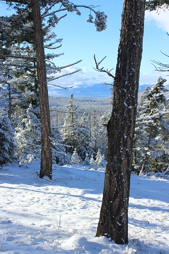
While it was gray down in the valley, we were rewarded with a bit of blue sky, 4 to 6 inches of powder on top of trails that had been groomed the day before and few other people. The trails weren’t marked for the new season, but with an updated map downloaded to my iPhone, old maps still posted and experience skiing the area in the past we had no trouble finding our way.
We decided to follow the new “E” trail, which is listed at about 7 3/4 miles and ends at an overlook.
After leaving the parking lot and passing through a gate slightly to the southeast, we followed the southern portions of the “C” and “D” loops generally to the east. The powder-covered trail rose and fell through the forest, and we stopped at a couple of junctions to check our directions.

Where the old “E” loop rejoined “D,” we followed it uphill more steeply into thicker trees. After switching back to the west, the forest thinned and we arrived at a downed tree that had blocked the groomer from continuing. We rounded the trunk and found ourselves in deeper, but still passable, powder and continued on, following a set of ski tracks.
Uphill a ways farther, the trees opened up and we could see the surrounding Blackfoot Valley and north to the Swan Mountains. After arriving at high point among the trees that was probably the overlook, we continued a short distance in the ski tracks before turning back.

After returning to the “C” and “D” loops and slowing for a tired dog, we passed a few other parties of skiers enjoying the day on the way back to the start.
Here are more photos from Lubrecht Experimental Forest.
Distance: 7 3/4 miles out and back. (We went a short distance farther, totaling about 8 1/4 miles.)
Trailhead: Follow Interstate 90 about 5 miles east of Missoula to Bonner, then Montana Highway 200 east 26 miles to Lubrecht Experimental Forest.
